You are here: Home > Network List > TA - USArray Transportable Network (new EarthScope stations) Stations List
> Station Q56A Snyder Ridge, Maysville, WV, USA > Earthquake Result Viewer
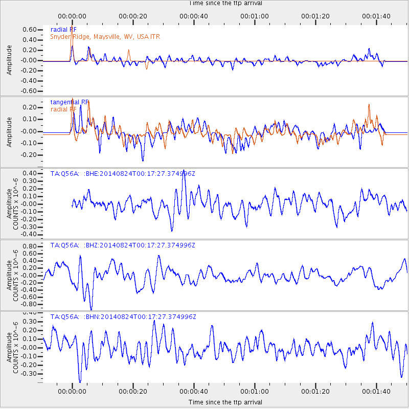
Q56A Snyder Ridge, Maysville, WV, USA - Earthquake Result Viewer
*The percent match for this event was below the threshold and hence no stack was calculated.
| Earthquake location: |
Iceland |
| Earthquake latitude/longitude: |
64.7/-17.4 |
| Earthquake time(UTC): |
2014/08/24 (236) 00:09:53 GMT |
| Earthquake Depth: |
6.2 km |
| Earthquake Magnitude: |
5.3 MW, 5.3 mb |
| Earthquake Catalog/Contributor: |
ISC/ISC |
|
| Network: |
TA USArray Transportable Network (new EarthScope stations) |
| Station: |
Q56A Snyder Ridge, Maysville, WV, USA |
| Lat/Lon: |
39.04 N/79.19 W |
| Elevation: |
430 m |
|
| Distance: |
43.5 deg |
| Az: |
264.753 deg |
| Baz: |
33.373 deg |
| Ray Param: |
$rayparam |
*The percent match for this event was below the threshold and hence was not used in the summary stack. |
|
| Radial Match: |
67.06756 % |
| Radial Bump: |
400 |
| Transverse Match: |
70.55212 % |
| Transverse Bump: |
400 |
| SOD ConfigId: |
3390531 |
| Insert Time: |
2019-04-13 13:58:58.469 +0000 |
| GWidth: |
2.5 |
| Max Bumps: |
400 |
| Tol: |
0.001 |
|
Signal To Noise
| Channel | StoN | STA | LTA |
| TA:Q56A: :BHZ:20140824T00:17:27.374996Z | 2.0785387 | 3.4492857E-7 | 1.6594764E-7 |
| TA:Q56A: :BHN:20140824T00:17:27.374996Z | 1.2871416 | 1.7806744E-7 | 1.3834331E-7 |
| TA:Q56A: :BHE:20140824T00:17:27.374996Z | 2.3287604 | 1.5456104E-7 | 6.6370525E-8 |
| Arrivals |
| Ps | |
| PpPs | |
| PsPs/PpSs | |


