You are here: Home > Network List > TA - USArray Transportable Network (new EarthScope stations) Stations List
> Station S51A Beattyville, KY, USA > Earthquake Result Viewer
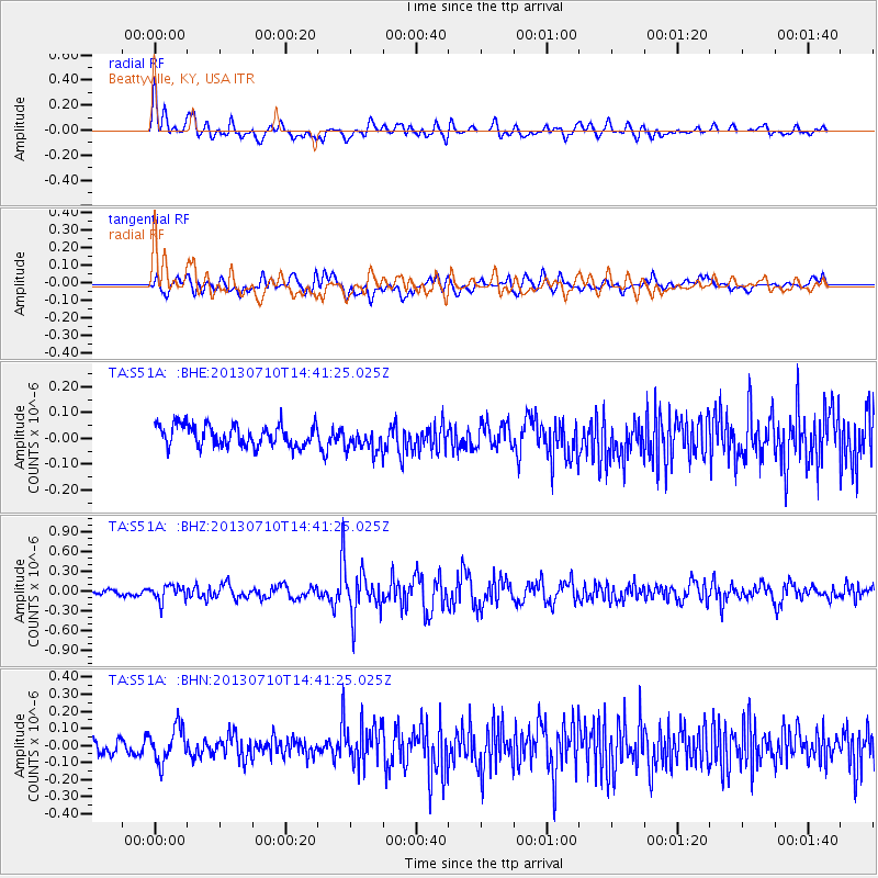
S51A Beattyville, KY, USA - Earthquake Result Viewer
*The percent match for this event was below the threshold and hence no stack was calculated.
| Earthquake location: |
Northern Chile |
| Earthquake latitude/longitude: |
-19.3/-69.2 |
| Earthquake time(UTC): |
2013/07/10 (191) 14:32:12 GMT |
| Earthquake Depth: |
110 km |
| Earthquake Magnitude: |
5.7 MW, 5.6 MW, 5.7 MB |
| Earthquake Catalog/Contributor: |
NEIC PDE/NEIC PDE-W |
|
| Network: |
TA USArray Transportable Network (new EarthScope stations) |
| Station: |
S51A Beattyville, KY, USA |
| Lat/Lon: |
37.64 N/83.59 W |
| Elevation: |
286 m |
|
| Distance: |
58.2 deg |
| Az: |
346.622 deg |
| Baz: |
164.022 deg |
| Ray Param: |
$rayparam |
*The percent match for this event was below the threshold and hence was not used in the summary stack. |
|
| Radial Match: |
61.86903 % |
| Radial Bump: |
400 |
| Transverse Match: |
57.880962 % |
| Transverse Bump: |
400 |
| SOD ConfigId: |
512894 |
| Insert Time: |
2013-09-15 18:07:02.244 +0000 |
| GWidth: |
2.5 |
| Max Bumps: |
400 |
| Tol: |
0.001 |
|
Signal To Noise
| Channel | StoN | STA | LTA |
| TA:S51A: :BHZ:20130710T14:41:25.025Z | 2.3212051 | 1.1932566E-7 | 5.140677E-8 |
| TA:S51A: :BHN:20130710T14:41:25.025Z | 2.9144652 | 1.0421129E-7 | 3.5756575E-8 |
| TA:S51A: :BHE:20130710T14:41:25.025Z | 1.1632721 | 4.7160874E-8 | 4.0541565E-8 |
| Arrivals |
| Ps | |
| PpPs | |
| PsPs/PpSs | |


