You are here: Home > Network List > TA - USArray Transportable Network (new EarthScope stations) Stations List
> Station W49A Belvidere, TN, USA > Earthquake Result Viewer
W49A Belvidere, TN, USA - Earthquake Result Viewer

| Earthquake location: |
Northern Chile |
| Earthquake latitude/longitude: |
-19.3/-69.2 |
| Earthquake time(UTC): |
2013/07/10 (191) 14:32:12 GMT |
| Earthquake Depth: |
110 km |
| Earthquake Magnitude: |
5.7 MW, 5.6 MW, 5.7 MB |
| Earthquake Catalog/Contributor: |
NEIC PDE/NEIC PDE-W |
|
| Network: |
TA USArray Transportable Network (new EarthScope stations) |
| Station: |
W49A Belvidere, TN, USA |
| Lat/Lon: |
35.12 N/86.26 W |
| Elevation: |
251 m |
|
| Distance: |
56.5 deg |
| Az: |
343.277 deg |
| Baz: |
160.639 deg |
| Ray Param: |
0.06377642 |
| Estimated Moho Depth: |
65.0 km |
| Estimated Crust Vp/Vs: |
1.70 |
| Assumed Crust Vp: |
6.476 km/s |
| Estimated Crust Vs: |
3.821 km/s |
| Estimated Crust Poisson's Ratio: |
0.23 |
|
| Radial Match: |
81.61085 % |
| Radial Bump: |
400 |
| Transverse Match: |
60.418507 % |
| Transverse Bump: |
400 |
| SOD ConfigId: |
512894 |
| Insert Time: |
2013-09-15 18:10:27.329 +0000 |
| GWidth: |
2.5 |
| Max Bumps: |
400 |
| Tol: |
0.001 |
|
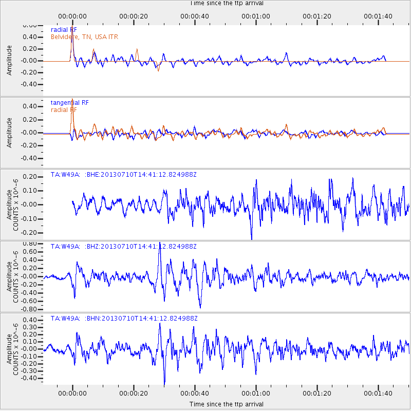
Signal To Noise
| Channel | StoN | STA | LTA |
| TA:W49A: :BHZ:20130710T14:41:12.824988Z | 6.0938077 | 2.1655752E-7 | 3.5537308E-8 |
| TA:W49A: :BHN:20130710T14:41:12.824988Z | 3.1833436 | 1.0935885E-7 | 3.435345E-8 |
| TA:W49A: :BHE:20130710T14:41:12.824988Z | 1.9144673 | 6.7649154E-8 | 3.533576E-8 |
| Arrivals |
| Ps | 7.4 SECOND |
| PpPs | 26 SECOND |
| PsPs/PpSs | 33 SECOND |


