You are here: Home > Network List > TA - USArray Transportable Network (new EarthScope stations) Stations List
> Station Z49A Columbiana, AL, USA > Earthquake Result Viewer
Z49A Columbiana, AL, USA - Earthquake Result Viewer

| Earthquake location: |
Northern Chile |
| Earthquake latitude/longitude: |
-19.3/-69.2 |
| Earthquake time(UTC): |
2013/07/10 (191) 14:32:12 GMT |
| Earthquake Depth: |
110 km |
| Earthquake Magnitude: |
5.7 MW, 5.6 MW, 5.7 MB |
| Earthquake Catalog/Contributor: |
NEIC PDE/NEIC PDE-W |
|
| Network: |
TA USArray Transportable Network (new EarthScope stations) |
| Station: |
Z49A Columbiana, AL, USA |
| Lat/Lon: |
33.19 N/86.53 W |
| Elevation: |
134 m |
|
| Distance: |
54.8 deg |
| Az: |
342.239 deg |
| Baz: |
159.904 deg |
| Ray Param: |
0.0649006 |
| Estimated Moho Depth: |
39.5 km |
| Estimated Crust Vp/Vs: |
1.95 |
| Assumed Crust Vp: |
6.565 km/s |
| Estimated Crust Vs: |
3.366 km/s |
| Estimated Crust Poisson's Ratio: |
0.32 |
|
| Radial Match: |
81.11595 % |
| Radial Bump: |
400 |
| Transverse Match: |
54.017647 % |
| Transverse Bump: |
400 |
| SOD ConfigId: |
512894 |
| Insert Time: |
2013-09-15 18:12:16.647 +0000 |
| GWidth: |
2.5 |
| Max Bumps: |
400 |
| Tol: |
0.001 |
|
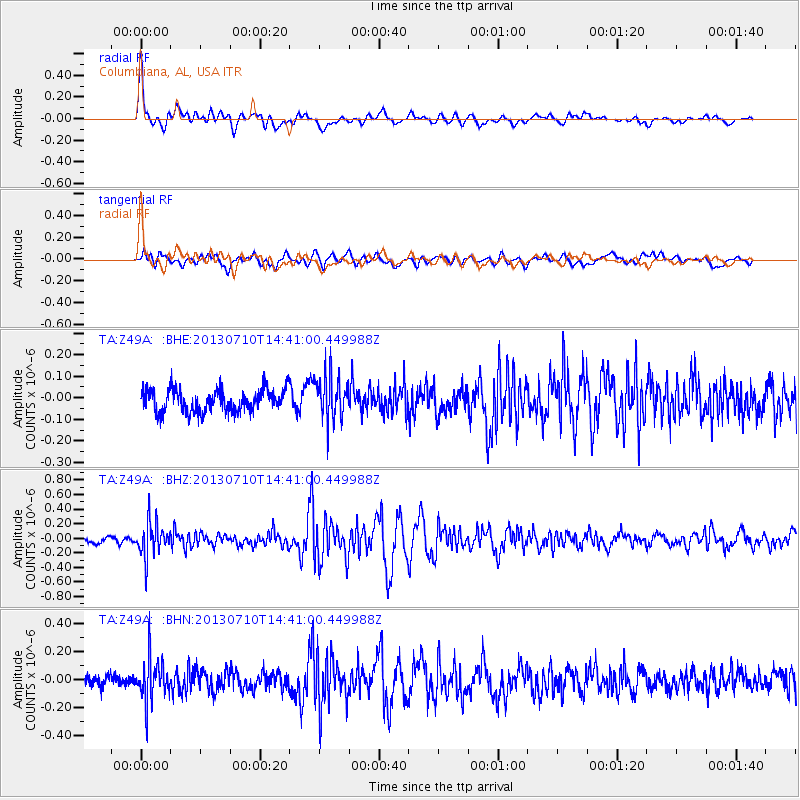
Signal To Noise
| Channel | StoN | STA | LTA |
| TA:Z49A: :BHZ:20130710T14:41:00.449988Z | 3.7390735 | 2.278662E-7 | 6.0941886E-8 |
| TA:Z49A: :BHN:20130710T14:41:00.449988Z | 3.6254325 | 1.499301E-7 | 4.1355094E-8 |
| TA:Z49A: :BHE:20130710T14:41:00.449988Z | 2.040004 | 1.06928546E-7 | 5.241585E-8 |
| Arrivals |
| Ps | 6.0 SECOND |
| PpPs | 17 SECOND |
| PsPs/PpSs | 23 SECOND |


