You are here: Home > Network List > UW - Pacific Northwest Regional Seismic Network Stations List
> Station SSW Satsop (broad-band) > Earthquake Result Viewer
SSW Satsop (broad-band) - Earthquake Result Viewer
| Earthquake location: |
Near East Coast Of Kamchatka |
| Earthquake latitude/longitude: |
51.2/157.8 |
| Earthquake time(UTC): |
1993/06/08 (159) 13:03:37 GMT |
| Earthquake Depth: |
81 km |
| Earthquake Magnitude: |
6.4 MB, 7.3 MS |
| Earthquake Catalog/Contributor: |
WHDF/NEIC |
|
| Network: |
UW Pacific Northwest Regional Seismic Network |
| Station: |
SSW Satsop (broad-band) |
| Lat/Lon: |
46.97 N/123.43 W |
| Elevation: |
120 m |
|
| Distance: |
49.4 deg |
| Az: |
62.189 deg |
| Baz: |
305.679 deg |
| Ray Param: |
0.0684778 |
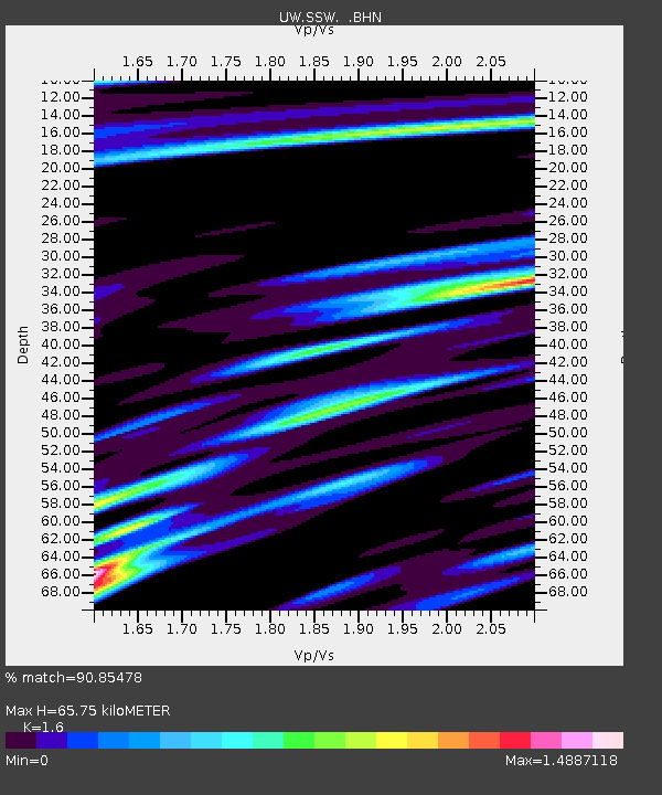
| Estimated Moho Depth: |
65.75 km |
| Estimated Crust Vp/Vs: |
1.60 |
| Assumed Crust Vp: |
6.566 km/s |
| Estimated Crust Vs: |
4.104 km/s |
| Estimated Crust Poisson's Ratio: |
0.18 |
|
| Radial Match: |
90.85478 % |
| Radial Bump: |
400 |
| Transverse Match: |
75.478325 % |
| Transverse Bump: |
400 |
| SOD ConfigId: |
16938 |
| Insert Time: |
2010-02-27 05:01:07.375 +0000 |
| GWidth: |
2.5 |
| Max Bumps: |
400 |
| Tol: |
0.001 |
|
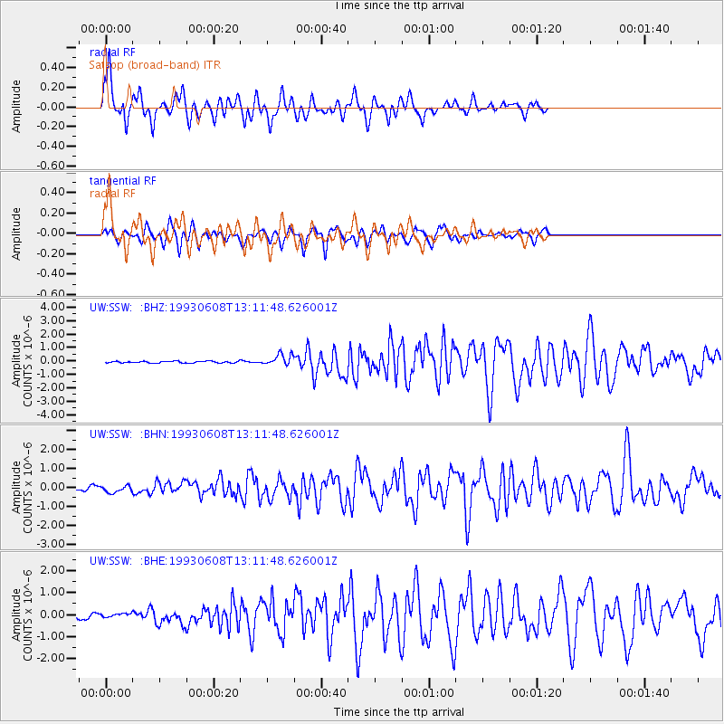
Signal To Noise
| Channel | StoN | STA | LTA |
| UW:SSW: :BHN:19930608T13:11:48.626001Z | 1.4601846 | 1.731512E-7 | 1.1858172E-7 |
| UW:SSW: :BHE:19930608T13:11:48.626001Z | 0.605287 | 8.6169926E-8 | 1.423621E-7 |
| UW:SSW: :BHZ:19930608T13:11:48.626001Z | 6.765728 | 4.256368E-7 | 6.2910715E-8 |
| Arrivals |
| Ps | 6.4 SECOND |
| PpPs | 24 SECOND |
| PsPs/PpSs | 31 SECOND |


