SSW Satsop (broad-band) - Earthquake Result Viewer
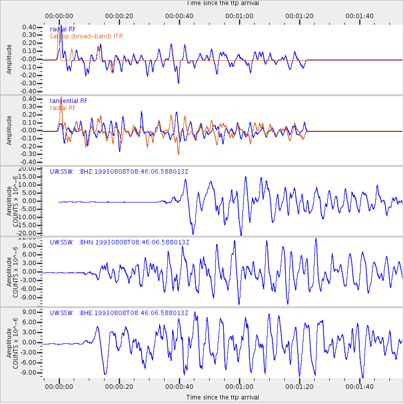
Earthquake location: South Of Mariana Islands
Earthquake latitude/longitude: 13.0/144.8
Earthquake time(UTC): 1993/08/08 (220) 08:34:25 GMT
Earthquake Depth: 61 km
Earthquake Magnitude: 7.2 MB, 8.1 MS, 8.2 UNKNOWN, 7.5 MW
Earthquake Catalog/Contributor: WHDF/NEIC
Network: UW Pacific Northwest Regional Seismic Network
Station: SSW Satsop (broad-band)
Lat/Lon: 46.97 N/123.43 W
Elevation: 120 m
Distance: 81.9 deg
Az: 43.743 deg
Baz: 280.173 deg
Ray Param: 0.04717256
Estimated Moho Depth: 65.5 km
Estimated Crust Vp/Vs: 1.60
Assumed Crust Vp: 6.566 km/s
Estimated Crust Vs: 4.104 km/s
Estimated Crust Poisson's Ratio: 0.18
Radial Match: 83.632904 %
Radial Bump: 381
Transverse Match: 88.06456 %
Transverse Bump: 400
SOD ConfigId: 16938
Insert Time: 2010-02-27 05:01:13.973 +0000
GWidth: 2.5
Max Bumps: 400
Tol: 0.001

Signal To Noise

ChannelStoNSTALTA
UW:SSW: :BHN:19930808T08:46:06.588013Z1.11279176.675641E-85.999003E-8
UW:SSW: :BHE:19930808T08:46:06.588013Z0.50148789.1340326E-81.8213868E-7
UW:SSW: :BHZ:19930808T08:46:06.588013Z6.1688552.8218838E-74.574404E-8
Arrivals
Ps6.2 SECOND
PpPs25 SECOND
PsPs/PpSs31 SECOND