You are here: Home > Network List > UW - Pacific Northwest Regional Seismic Network Stations List
> Station PASS Maple Falls, WA, USA > Earthquake Result Viewer
PASS Maple Falls, WA, USA - Earthquake Result Viewer
| Earthquake location: |
Kermadec Islands, New Zealand |
| Earthquake latitude/longitude: |
-30.2/-177.5 |
| Earthquake time(UTC): |
2013/07/10 (191) 14:44:01 GMT |
| Earthquake Depth: |
10 km |
| Earthquake Magnitude: |
5.6 MW, 5.5 MB, 5.6 MW |
| Earthquake Catalog/Contributor: |
NEIC PDE/NEIC PDE-W |
|
| Network: |
UW Pacific Northwest Regional Seismic Network |
| Station: |
PASS Maple Falls, WA, USA |
| Lat/Lon: |
49.00 N/122.09 W |
| Elevation: |
174 m |
|
| Distance: |
93.1 deg |
| Az: |
32.903 deg |
| Baz: |
225.543 deg |
| Ray Param: |
0.041329496 |
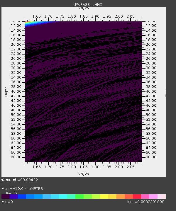
| Estimated Moho Depth: |
10.0 km |
| Estimated Crust Vp/Vs: |
1.60 |
| Assumed Crust Vp: |
6.566 km/s |
| Estimated Crust Vs: |
4.104 km/s |
| Estimated Crust Poisson's Ratio: |
0.18 |
|
| Radial Match: |
99.99422 % |
| Radial Bump: |
2 |
| Transverse Match: |
99.66021 % |
| Transverse Bump: |
26 |
| SOD ConfigId: |
512894 |
| Insert Time: |
2013-09-15 18:36:37.587 +0000 |
| GWidth: |
2.5 |
| Max Bumps: |
400 |
| Tol: |
0.001 |
|
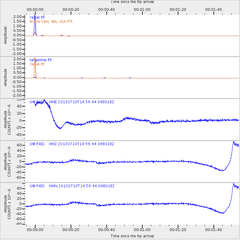
Signal To Noise
| Channel | StoN | STA | LTA |
| UW:PASS: :HHZ:20130710T14:56:44.048018Z | 0.5276993 | 1.2665471E-5 | 2.4001303E-5 |
| UW:PASS: :HHN:20130710T14:56:44.048018Z | 0.5289084 | 1.3645505E-5 | 2.5799372E-5 |
| UW:PASS: :HHE:20130710T14:56:44.048018Z | 0.52176625 | 1.481951E-5 | 2.8402588E-5 |
| Arrivals |
| Ps | 0.9 SECOND |
| PpPs | 3.9 SECOND |
| PsPs/PpSs | 4.8 SECOND |


