You are here: Home > Network List > UW - Pacific Northwest Regional Seismic Network Stations List
> Station SSW Satsop (broad-band) > Earthquake Result Viewer
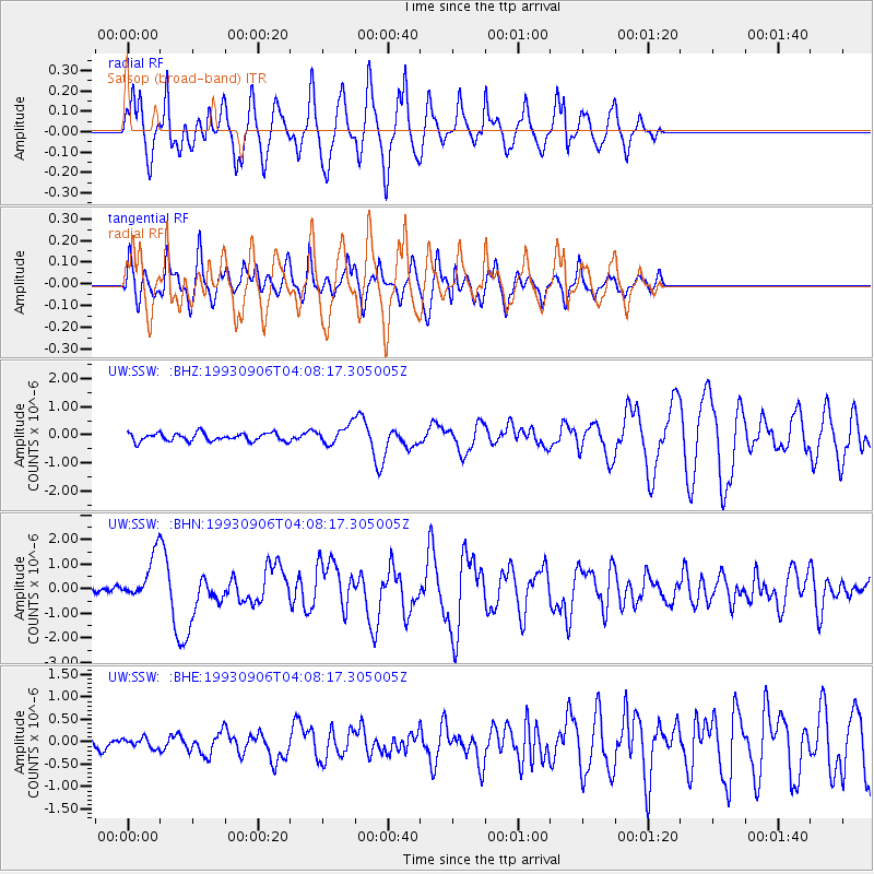
SSW Satsop (broad-band) - Earthquake Result Viewer
*The percent match for this event was below the threshold and hence no stack was calculated.
| Earthquake location: |
New Ireland Region, P.N.G. |
| Earthquake latitude/longitude: |
-4.7/153.2 |
| Earthquake time(UTC): |
1993/09/06 (249) 03:56:02 GMT |
| Earthquake Depth: |
73 km |
| Earthquake Magnitude: |
6.0 MB, 6.6 MS, 6.7 UNKNOWN, 6.6 MW |
| Earthquake Catalog/Contributor: |
WHDF/NEIC |
|
| Network: |
UW Pacific Northwest Regional Seismic Network |
| Station: |
SSW Satsop (broad-band) |
| Lat/Lon: |
46.97 N/123.43 W |
| Elevation: |
120 m |
|
| Distance: |
88.9 deg |
| Az: |
42.869 deg |
| Baz: |
261.954 deg |
| Ray Param: |
$rayparam |
*The percent match for this event was below the threshold and hence was not used in the summary stack. |
|
| Radial Match: |
85.393295 % |
| Radial Bump: |
382 |
| Transverse Match: |
84.92432 % |
| Transverse Bump: |
400 |
| SOD ConfigId: |
4480 |
| Insert Time: |
2010-02-27 05:01:51.930 +0000 |
| GWidth: |
2.5 |
| Max Bumps: |
400 |
| Tol: |
0.001 |
|
Signal To Noise
| Channel | StoN | STA | LTA |
| UW:SSW: :BHN:19930906T04:08:17.305005Z | 7.626596 | 8.9436804E-7 | 1.1726962E-7 |
| UW:SSW: :BHE:19930906T04:08:17.305005Z | 0.84578925 | 1.0596807E-7 | 1.2528898E-7 |
| UW:SSW: :BHZ:19930906T04:08:17.305005Z | 2.2633514 | 3.1893353E-7 | 1.4091206E-7 |
| Arrivals |
| Ps | |
| PpPs | |
| PsPs/PpSs | |


