You are here: Home > Network List > AK - Alaska Regional Network Stations List
> Station MDM Murphy Dome > Earthquake Result Viewer
MDM Murphy Dome - Earthquake Result Viewer
*The percent match for this event was below the threshold and hence no stack was calculated.
| Earthquake location: |
Tonga Islands |
| Earthquake latitude/longitude: |
-15.4/-173.1 |
| Earthquake time(UTC): |
2013/07/15 (196) 13:59:04 GMT |
| Earthquake Depth: |
15 km |
| Earthquake Magnitude: |
5.8 MW, 5.5 MB, 5.8 MW |
| Earthquake Catalog/Contributor: |
NEIC PDE/NEIC PDE-W |
|
| Network: |
AK Alaska Regional Network |
| Station: |
MDM Murphy Dome |
| Lat/Lon: |
64.96 N/148.23 W |
| Elevation: |
634 m |
|
| Distance: |
82.3 deg |
| Az: |
10.402 deg |
| Baz: |
204.154 deg |
| Ray Param: |
$rayparam |
*The percent match for this event was below the threshold and hence was not used in the summary stack. |
|
| Radial Match: |
62.522484 % |
| Radial Bump: |
400 |
| Transverse Match: |
50.01625 % |
| Transverse Bump: |
400 |
| SOD ConfigId: |
512894 |
| Insert Time: |
2013-09-15 18:55:59.178 +0000 |
| GWidth: |
2.5 |
| Max Bumps: |
400 |
| Tol: |
0.001 |
|
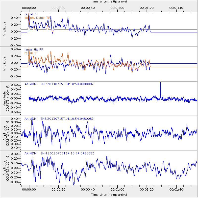
Signal To Noise
| Channel | StoN | STA | LTA |
| AK:MDM: :BHZ:20130715T14:10:54.048008Z | 3.0952585 | 1.9308119E-7 | 6.237966E-8 |
| AK:MDM: :BHN:20130715T14:10:54.048008Z | 2.3827286 | 1.12377236E-7 | 4.7163255E-8 |
| AK:MDM: :BHE:20130715T14:10:54.048008Z | 1.801478 | 1.0751183E-7 | 5.967979E-8 |
| Arrivals |
| Ps | |
| PpPs | |
| PsPs/PpSs | |


