You are here: Home > Network List > IW - Intermountain West Stations List
> Station MOOW Moose Ponds, Wyoming, USA > Earthquake Result Viewer
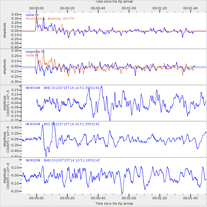
MOOW Moose Ponds, Wyoming, USA - Earthquake Result Viewer
*The percent match for this event was below the threshold and hence no stack was calculated.
| Earthquake location: |
Tonga Islands |
| Earthquake latitude/longitude: |
-15.4/-173.1 |
| Earthquake time(UTC): |
2013/07/15 (196) 13:59:04 GMT |
| Earthquake Depth: |
15 km |
| Earthquake Magnitude: |
5.8 MW, 5.5 MB, 5.8 MW |
| Earthquake Catalog/Contributor: |
NEIC PDE/NEIC PDE-W |
|
| Network: |
IW Intermountain West |
| Station: |
MOOW Moose Ponds, Wyoming, USA |
| Lat/Lon: |
43.75 N/110.74 W |
| Elevation: |
2128 m |
|
| Distance: |
81.8 deg |
| Az: |
40.431 deg |
| Baz: |
239.677 deg |
| Ray Param: |
$rayparam |
*The percent match for this event was below the threshold and hence was not used in the summary stack. |
|
| Radial Match: |
66.79688 % |
| Radial Bump: |
400 |
| Transverse Match: |
73.07902 % |
| Transverse Bump: |
400 |
| SOD ConfigId: |
512894 |
| Insert Time: |
2013-09-15 19:08:56.748 +0000 |
| GWidth: |
2.5 |
| Max Bumps: |
400 |
| Tol: |
0.001 |
|
Signal To Noise
| Channel | StoN | STA | LTA |
| IW:MOOW: :BHZ:20130715T14:10:51.365024Z | 4.793297 | 2.0299365E-7 | 4.2349484E-8 |
| IW:MOOW: :BHN:20130715T14:10:51.365024Z | 1.2936485 | 5.0733927E-8 | 3.9217706E-8 |
| IW:MOOW: :BHE:20130715T14:10:51.365024Z | 2.1543088 | 8.2214676E-8 | 3.8162902E-8 |
| Arrivals |
| Ps | |
| PpPs | |
| PsPs/PpSs | |


