You are here: Home > Network List > TA - USArray Transportable Network (new EarthScope stations) Stations List
> Station L40A Anamosa, IA, USA > Earthquake Result Viewer
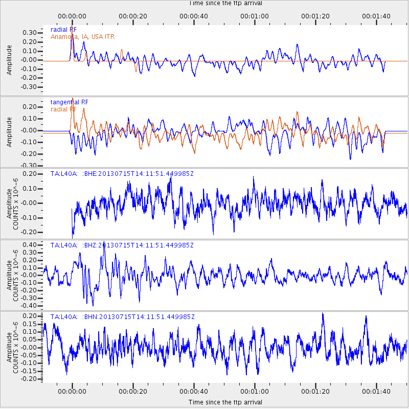
L40A Anamosa, IA, USA - Earthquake Result Viewer
*The percent match for this event was below the threshold and hence no stack was calculated.
| Earthquake location: |
Tonga Islands |
| Earthquake latitude/longitude: |
-15.4/-173.1 |
| Earthquake time(UTC): |
2013/07/15 (196) 13:59:04 GMT |
| Earthquake Depth: |
15 km |
| Earthquake Magnitude: |
5.8 MW, 5.5 MB, 5.8 MW |
| Earthquake Catalog/Contributor: |
NEIC PDE/NEIC PDE-W |
|
| Network: |
TA USArray Transportable Network (new EarthScope stations) |
| Station: |
L40A Anamosa, IA, USA |
| Lat/Lon: |
42.06 N/91.22 W |
| Elevation: |
242 m |
|
| Distance: |
94.3 deg |
| Az: |
47.664 deg |
| Baz: |
253.24 deg |
| Ray Param: |
$rayparam |
*The percent match for this event was below the threshold and hence was not used in the summary stack. |
|
| Radial Match: |
52.355164 % |
| Radial Bump: |
400 |
| Transverse Match: |
54.375046 % |
| Transverse Bump: |
400 |
| SOD ConfigId: |
512894 |
| Insert Time: |
2013-09-15 19:17:37.250 +0000 |
| GWidth: |
2.5 |
| Max Bumps: |
400 |
| Tol: |
0.001 |
|
Signal To Noise
| Channel | StoN | STA | LTA |
| TA:L40A: :BHZ:20130715T14:11:51.449985Z | 2.942382 | 1.7136084E-7 | 5.8238815E-8 |
| TA:L40A: :BHN:20130715T14:11:51.449985Z | 0.5560042 | 4.770883E-8 | 8.5806604E-8 |
| TA:L40A: :BHE:20130715T14:11:51.449985Z | 1.3171558 | 8.7785985E-8 | 6.6648134E-8 |
| Arrivals |
| Ps | |
| PpPs | |
| PsPs/PpSs | |


