You are here: Home > Network List > TA - USArray Transportable Network (new EarthScope stations) Stations List
> Station TCOL CIGO, UAF Yankovich Road, Fairbanks, AK, USA > Earthquake Result Viewer
TCOL CIGO, UAF Yankovich Road, Fairbanks, AK, USA - Earthquake Result Viewer
| Earthquake location: |
Tonga Islands |
| Earthquake latitude/longitude: |
-15.4/-173.1 |
| Earthquake time(UTC): |
2013/07/15 (196) 13:59:04 GMT |
| Earthquake Depth: |
15 km |
| Earthquake Magnitude: |
5.8 MW, 5.5 MB, 5.8 MW |
| Earthquake Catalog/Contributor: |
NEIC PDE/NEIC PDE-W |
|
| Network: |
TA USArray Transportable Network (new EarthScope stations) |
| Station: |
TCOL CIGO, UAF Yankovich Road, Fairbanks, AK, USA |
| Lat/Lon: |
64.87 N/147.86 W |
| Elevation: |
178 m |
|
| Distance: |
82.3 deg |
| Az: |
10.582 deg |
| Baz: |
204.51 deg |
| Ray Param: |
0.046972103 |
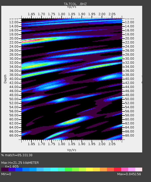
| Estimated Moho Depth: |
21.25 km |
| Estimated Crust Vp/Vs: |
1.61 |
| Assumed Crust Vp: |
6.566 km/s |
| Estimated Crust Vs: |
4.091 km/s |
| Estimated Crust Poisson's Ratio: |
0.18 |
|
| Radial Match: |
85.33138 % |
| Radial Bump: |
400 |
| Transverse Match: |
76.186714 % |
| Transverse Bump: |
400 |
| SOD ConfigId: |
512894 |
| Insert Time: |
2013-09-15 19:19:17.352 +0000 |
| GWidth: |
2.5 |
| Max Bumps: |
400 |
| Tol: |
0.001 |
|

Signal To Noise
| Channel | StoN | STA | LTA |
| TA:TCOL: :BHZ:20130715T14:10:53.97501Z | 8.629177 | 5.258993E-7 | 6.0944316E-8 |
| TA:TCOL: :BHN:20130715T14:10:53.97501Z | 4.0534644 | 2.4897923E-7 | 6.142381E-8 |
| TA:TCOL: :BHE:20130715T14:10:53.97501Z | 2.797017 | 1.6201483E-7 | 5.7924144E-8 |
| Arrivals |
| Ps | 2.0 SECOND |
| PpPs | 8.2 SECOND |
| PsPs/PpSs | 10 SECOND |


