You are here: Home > Network List > TA - USArray Transportable Network (new EarthScope stations) Stations List
> Station V46A Holladay, TN, USA > Earthquake Result Viewer
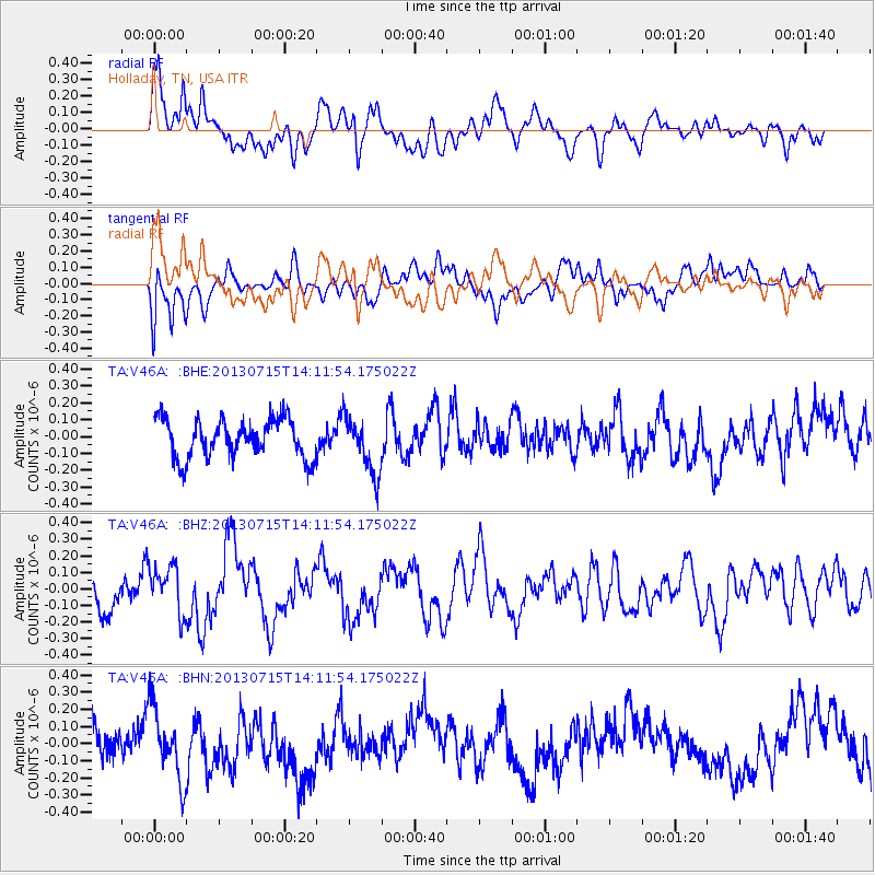
V46A Holladay, TN, USA - Earthquake Result Viewer
*The percent match for this event was below the threshold and hence no stack was calculated.
| Earthquake location: |
Tonga Islands |
| Earthquake latitude/longitude: |
-15.4/-173.1 |
| Earthquake time(UTC): |
2013/07/15 (196) 13:59:04 GMT |
| Earthquake Depth: |
15 km |
| Earthquake Magnitude: |
5.8 MW, 5.5 MB, 5.8 MW |
| Earthquake Catalog/Contributor: |
NEIC PDE/NEIC PDE-W |
|
| Network: |
TA USArray Transportable Network (new EarthScope stations) |
| Station: |
V46A Holladay, TN, USA |
| Lat/Lon: |
35.80 N/88.12 W |
| Elevation: |
162 m |
|
| Distance: |
94.9 deg |
| Az: |
54.363 deg |
| Baz: |
254.651 deg |
| Ray Param: |
$rayparam |
*The percent match for this event was below the threshold and hence was not used in the summary stack. |
|
| Radial Match: |
39.022087 % |
| Radial Bump: |
400 |
| Transverse Match: |
35.318283 % |
| Transverse Bump: |
400 |
| SOD ConfigId: |
512894 |
| Insert Time: |
2013-09-15 19:19:48.982 +0000 |
| GWidth: |
2.5 |
| Max Bumps: |
400 |
| Tol: |
0.001 |
|
Signal To Noise
| Channel | StoN | STA | LTA |
| TA:V46A: :BHZ:20130715T14:11:54.175022Z | 1.518766 | 1.4698657E-7 | 9.678026E-8 |
| TA:V46A: :BHN:20130715T14:11:54.175022Z | 1.3597009 | 2.0748777E-7 | 1.525981E-7 |
| TA:V46A: :BHE:20130715T14:11:54.175022Z | 1.5026793 | 1.721476E-7 | 1.1456043E-7 |
| Arrivals |
| Ps | |
| PpPs | |
| PsPs/PpSs | |


