You are here: Home > Network List > TA - USArray Transportable Network (new EarthScope stations) Stations List
> Station W52A Murphy, NC, USA > Earthquake Result Viewer
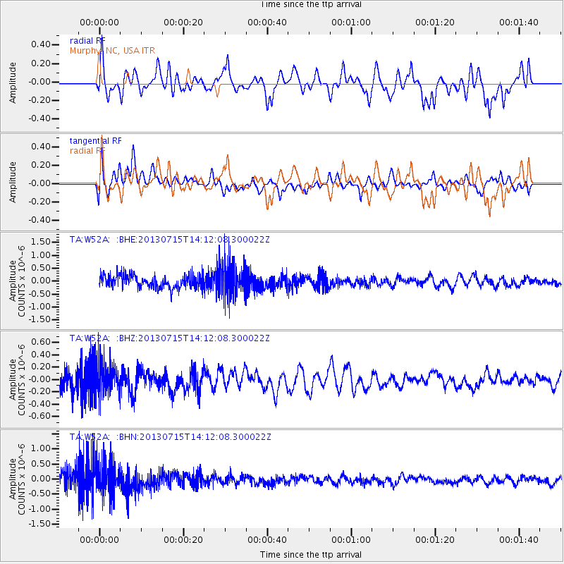
W52A Murphy, NC, USA - Earthquake Result Viewer
*The percent match for this event was below the threshold and hence no stack was calculated.
| Earthquake location: |
Tonga Islands |
| Earthquake latitude/longitude: |
-15.4/-173.1 |
| Earthquake time(UTC): |
2013/07/15 (196) 13:59:04 GMT |
| Earthquake Depth: |
15 km |
| Earthquake Magnitude: |
5.8 MW, 5.5 MB, 5.8 MW |
| Earthquake Catalog/Contributor: |
NEIC PDE/NEIC PDE-W |
|
| Network: |
TA USArray Transportable Network (new EarthScope stations) |
| Station: |
W52A Murphy, NC, USA |
| Lat/Lon: |
35.09 N/83.93 W |
| Elevation: |
519 m |
|
| Distance: |
98.0 deg |
| Az: |
55.897 deg |
| Baz: |
256.899 deg |
| Ray Param: |
$rayparam |
*The percent match for this event was below the threshold and hence was not used in the summary stack. |
|
| Radial Match: |
45.81844 % |
| Radial Bump: |
400 |
| Transverse Match: |
46.757442 % |
| Transverse Bump: |
400 |
| SOD ConfigId: |
512894 |
| Insert Time: |
2013-09-15 19:20:21.342 +0000 |
| GWidth: |
2.5 |
| Max Bumps: |
400 |
| Tol: |
0.001 |
|
Signal To Noise
| Channel | StoN | STA | LTA |
| TA:W52A: :BHZ:20130715T14:12:08.300022Z | 1.827956 | 2.5750433E-7 | 1.4087009E-7 |
| TA:W52A: :BHN:20130715T14:12:08.300022Z | 2.4352317 | 5.629399E-7 | 2.3116482E-7 |
| TA:W52A: :BHE:20130715T14:12:08.300022Z | 2.6626344 | 6.6065303E-7 | 2.4812007E-7 |
| Arrivals |
| Ps | |
| PpPs | |
| PsPs/PpSs | |


