You are here: Home > Network List > TA - USArray Transportable Network (new EarthScope stations) Stations List
> Station Y12C Blythe, CA, USA > Earthquake Result Viewer
Y12C Blythe, CA, USA - Earthquake Result Viewer
*The percent match for this event was below the threshold and hence no stack was calculated.
| Earthquake location: |
Tonga Islands |
| Earthquake latitude/longitude: |
-15.4/-173.1 |
| Earthquake time(UTC): |
2013/07/15 (196) 13:59:04 GMT |
| Earthquake Depth: |
15 km |
| Earthquake Magnitude: |
5.8 MW, 5.5 MB, 5.8 MW |
| Earthquake Catalog/Contributor: |
NEIC PDE/NEIC PDE-W |
|
| Network: |
TA USArray Transportable Network (new EarthScope stations) |
| Station: |
Y12C Blythe, CA, USA |
| Lat/Lon: |
33.75 N/114.52 W |
| Elevation: |
196 m |
|
| Distance: |
74.1 deg |
| Az: |
47.648 deg |
| Baz: |
238.821 deg |
| Ray Param: |
$rayparam |
*The percent match for this event was below the threshold and hence was not used in the summary stack. |
|
| Radial Match: |
69.55732 % |
| Radial Bump: |
400 |
| Transverse Match: |
62.928333 % |
| Transverse Bump: |
400 |
| SOD ConfigId: |
512894 |
| Insert Time: |
2013-09-15 19:20:50.586 +0000 |
| GWidth: |
2.5 |
| Max Bumps: |
400 |
| Tol: |
0.001 |
|
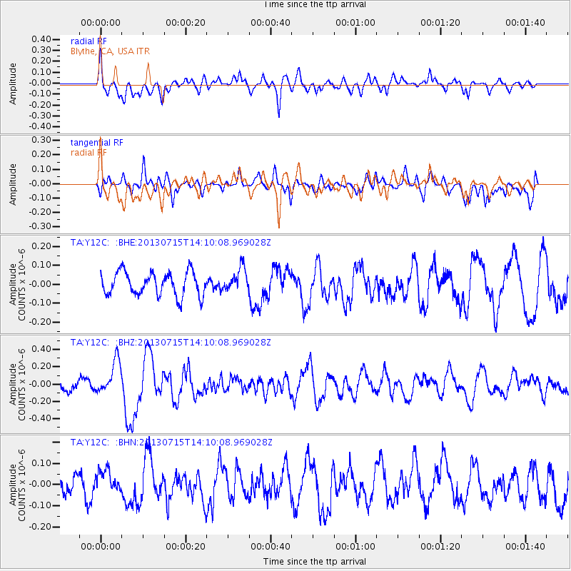
Signal To Noise
| Channel | StoN | STA | LTA |
| TA:Y12C: :BHZ:20130715T14:10:08.969028Z | 2.37977 | 2.0268936E-7 | 8.517183E-8 |
| TA:Y12C: :BHN:20130715T14:10:08.969028Z | 1.3561496 | 5.386225E-8 | 3.9717044E-8 |
| TA:Y12C: :BHE:20130715T14:10:08.969028Z | 1.0015041 | 6.204959E-8 | 6.19564E-8 |
| Arrivals |
| Ps | |
| PpPs | |
| PsPs/PpSs | |


