You are here: Home > Network List > US - United States National Seismic Network Stations List
> Station MSO Missoula, Montana, USA > Earthquake Result Viewer
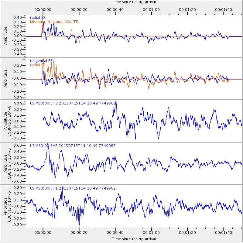
MSO Missoula, Montana, USA - Earthquake Result Viewer
*The percent match for this event was below the threshold and hence no stack was calculated.
| Earthquake location: |
Tonga Islands |
| Earthquake latitude/longitude: |
-15.4/-173.1 |
| Earthquake time(UTC): |
2013/07/15 (196) 13:59:04 GMT |
| Earthquake Depth: |
15 km |
| Earthquake Magnitude: |
5.8 MW, 5.5 MB, 5.8 MW |
| Earthquake Catalog/Contributor: |
NEIC PDE/NEIC PDE-W |
|
| Network: |
US United States National Seismic Network |
| Station: |
MSO Missoula, Montana, USA |
| Lat/Lon: |
46.83 N/113.94 W |
| Elevation: |
1264 m |
|
| Distance: |
81.5 deg |
| Az: |
36.585 deg |
| Baz: |
236.853 deg |
| Ray Param: |
$rayparam |
*The percent match for this event was below the threshold and hence was not used in the summary stack. |
|
| Radial Match: |
62.7306 % |
| Radial Bump: |
400 |
| Transverse Match: |
65.7167 % |
| Transverse Bump: |
400 |
| SOD ConfigId: |
512894 |
| Insert Time: |
2013-09-15 19:22:55.466 +0000 |
| GWidth: |
2.5 |
| Max Bumps: |
400 |
| Tol: |
0.001 |
|
Signal To Noise
| Channel | StoN | STA | LTA |
| US:MSO:00:BHZ:20130715T14:10:49.774998Z | 2.4467223 | 2.9329436E-7 | 1.1987235E-7 |
| US:MSO:00:BH1:20130715T14:10:49.774998Z | 1.5041484 | 9.539006E-8 | 6.341798E-8 |
| US:MSO:00:BH2:20130715T14:10:49.774998Z | 1.5887275 | 1.2473204E-7 | 7.851065E-8 |
| Arrivals |
| Ps | |
| PpPs | |
| PsPs/PpSs | |


