You are here: Home > Network List > TA - USArray Transportable Network (new EarthScope stations) Stations List
> Station G59A Clarenceville, QC, USA > Earthquake Result Viewer
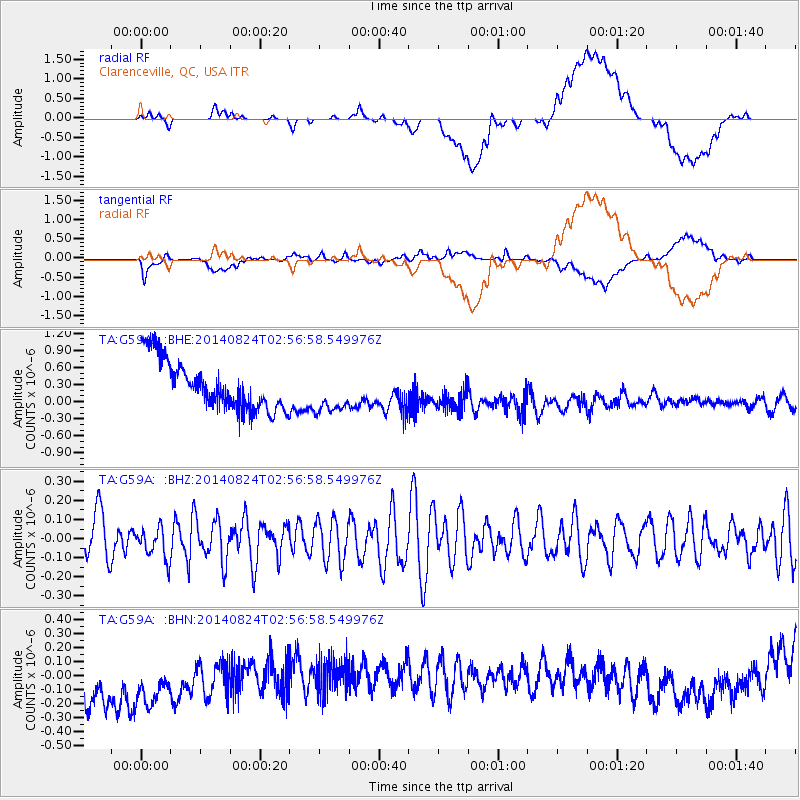
G59A Clarenceville, QC, USA - Earthquake Result Viewer
*The percent match for this event was below the threshold and hence no stack was calculated.
| Earthquake location: |
Iran-Iraq Border Region |
| Earthquake latitude/longitude: |
32.6/47.8 |
| Earthquake time(UTC): |
2014/08/24 (236) 02:44:50 GMT |
| Earthquake Depth: |
17 km |
| Earthquake Magnitude: |
5.1 MW, 5.3 mb |
| Earthquake Catalog/Contributor: |
ISC/ISC |
|
| Network: |
TA USArray Transportable Network (new EarthScope stations) |
| Station: |
G59A Clarenceville, QC, USA |
| Lat/Lon: |
45.08 N/73.18 W |
| Elevation: |
36 m |
|
| Distance: |
86.0 deg |
| Az: |
322.504 deg |
| Baz: |
46.515 deg |
| Ray Param: |
$rayparam |
*The percent match for this event was below the threshold and hence was not used in the summary stack. |
|
| Radial Match: |
20.87945 % |
| Radial Bump: |
400 |
| Transverse Match: |
33.007965 % |
| Transverse Bump: |
400 |
| SOD ConfigId: |
3390531 |
| Insert Time: |
2019-04-13 14:09:09.748 +0000 |
| GWidth: |
2.5 |
| Max Bumps: |
400 |
| Tol: |
0.001 |
|
Signal To Noise
| Channel | StoN | STA | LTA |
| TA:G59A: :BHZ:20140824T02:56:58.549976Z | 0.6988624 | 8.22981E-8 | 1.17760095E-7 |
| TA:G59A: :BHN:20140824T02:56:58.549976Z | 0.94187844 | 4.9394055E-7 | 5.244207E-7 |
| TA:G59A: :BHE:20140824T02:56:58.549976Z | 0.86825955 | 3.7256808E-7 | 4.2909758E-7 |
| Arrivals |
| Ps | |
| PpPs | |
| PsPs/PpSs | |


