You are here: Home > Network List > TA - USArray Transportable Network (new EarthScope stations) Stations List
> Station V56A Mocksville, NC, USA > Earthquake Result Viewer
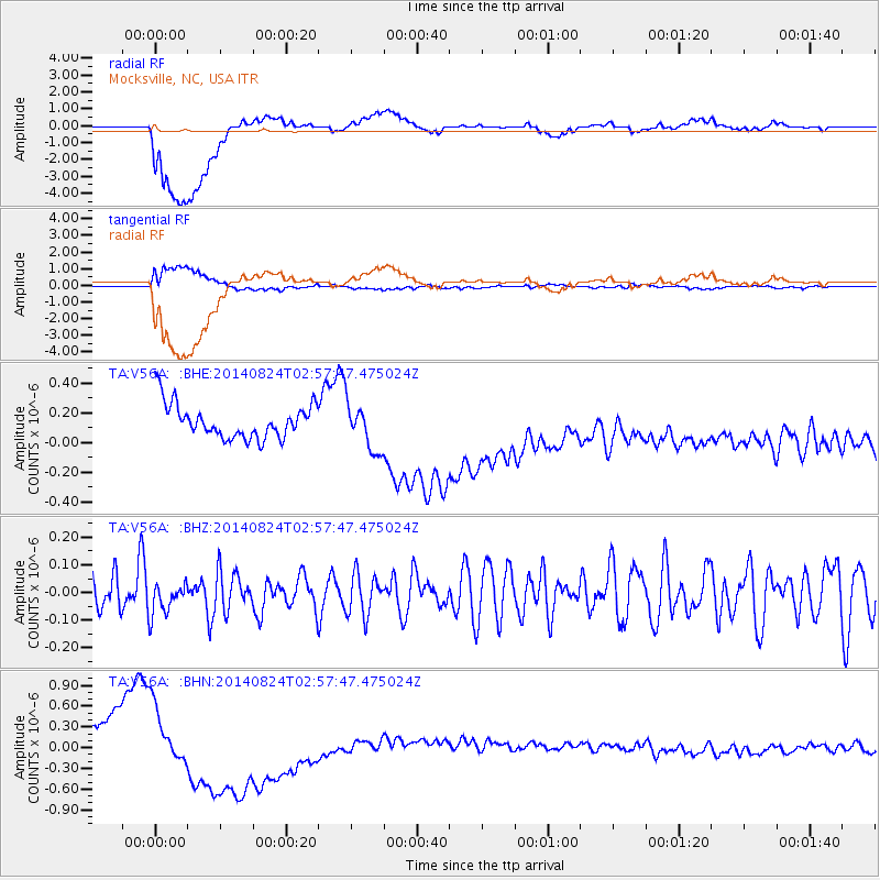
V56A Mocksville, NC, USA - Earthquake Result Viewer
*The percent match for this event was below the threshold and hence no stack was calculated.
| Earthquake location: |
Iran-Iraq Border Region |
| Earthquake latitude/longitude: |
32.6/47.8 |
| Earthquake time(UTC): |
2014/08/24 (236) 02:44:50 GMT |
| Earthquake Depth: |
17 km |
| Earthquake Magnitude: |
5.1 MW, 5.3 mb |
| Earthquake Catalog/Contributor: |
ISC/ISC |
|
| Network: |
TA USArray Transportable Network (new EarthScope stations) |
| Station: |
V56A Mocksville, NC, USA |
| Lat/Lon: |
35.81 N/80.50 W |
| Elevation: |
237 m |
|
| Distance: |
96.5 deg |
| Az: |
320.072 deg |
| Baz: |
41.822 deg |
| Ray Param: |
$rayparam |
*The percent match for this event was below the threshold and hence was not used in the summary stack. |
|
| Radial Match: |
43.719677 % |
| Radial Bump: |
400 |
| Transverse Match: |
46.910984 % |
| Transverse Bump: |
400 |
| SOD ConfigId: |
3390531 |
| Insert Time: |
2019-04-13 14:09:44.281 +0000 |
| GWidth: |
2.5 |
| Max Bumps: |
400 |
| Tol: |
0.001 |
|
Signal To Noise
| Channel | StoN | STA | LTA |
| TA:V56A: :BHZ:20140824T02:57:47.475024Z | 0.68173844 | 5.987479E-8 | 8.782663E-8 |
| TA:V56A: :BHN:20140824T02:57:47.475024Z | 1.5868137 | 3.7904528E-7 | 2.3887196E-7 |
| TA:V56A: :BHE:20140824T02:57:47.475024Z | 1.4033333 | 1.5973119E-7 | 1.138227E-7 |
| Arrivals |
| Ps | |
| PpPs | |
| PsPs/PpSs | |


