You are here: Home > Network List > TA - USArray Transportable Network (new EarthScope stations) Stations List
> Station X59A McDuffie Farm, Elizabethtown, NC, USA > Earthquake Result Viewer
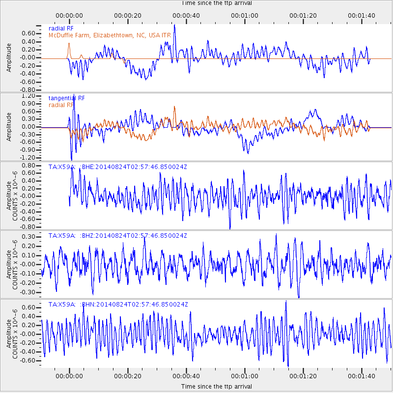
X59A McDuffie Farm, Elizabethtown, NC, USA - Earthquake Result Viewer
*The percent match for this event was below the threshold and hence no stack was calculated.
| Earthquake location: |
Iran-Iraq Border Region |
| Earthquake latitude/longitude: |
32.6/47.8 |
| Earthquake time(UTC): |
2014/08/24 (236) 02:44:50 GMT |
| Earthquake Depth: |
17 km |
| Earthquake Magnitude: |
5.1 MW, 5.3 mb |
| Earthquake Catalog/Contributor: |
ISC/ISC |
|
| Network: |
TA USArray Transportable Network (new EarthScope stations) |
| Station: |
X59A McDuffie Farm, Elizabethtown, NC, USA |
| Lat/Lon: |
34.57 N/78.60 W |
| Elevation: |
29 m |
|
| Distance: |
96.4 deg |
| Az: |
318.082 deg |
| Baz: |
43.133 deg |
| Ray Param: |
$rayparam |
*The percent match for this event was below the threshold and hence was not used in the summary stack. |
|
| Radial Match: |
50.656826 % |
| Radial Bump: |
400 |
| Transverse Match: |
47.64097 % |
| Transverse Bump: |
400 |
| SOD ConfigId: |
3390531 |
| Insert Time: |
2019-04-13 14:09:48.491 +0000 |
| GWidth: |
2.5 |
| Max Bumps: |
400 |
| Tol: |
0.001 |
|
Signal To Noise
| Channel | StoN | STA | LTA |
| TA:X59A: :BHZ:20140824T02:57:46.850024Z | 1.1584908 | 1.029158E-7 | 8.88361E-8 |
| TA:X59A: :BHN:20140824T02:57:46.850024Z | 1.2935553 | 3.337756E-7 | 2.5802962E-7 |
| TA:X59A: :BHE:20140824T02:57:46.850024Z | 1.1958836 | 2.8337027E-7 | 2.369547E-7 |
| Arrivals |
| Ps | |
| PpPs | |
| PsPs/PpSs | |


