You are here: Home > Network List > UW - Pacific Northwest Regional Seismic Network Stations List
> Station PASS Maple Falls, WA, USA > Earthquake Result Viewer
PASS Maple Falls, WA, USA - Earthquake Result Viewer
| Earthquake location: |
Tonga Islands |
| Earthquake latitude/longitude: |
-15.4/-173.1 |
| Earthquake time(UTC): |
2013/07/15 (196) 13:59:04 GMT |
| Earthquake Depth: |
15 km |
| Earthquake Magnitude: |
5.8 MW, 5.5 MB, 5.8 MW |
| Earthquake Catalog/Contributor: |
NEIC PDE/NEIC PDE-W |
|
| Network: |
UW Pacific Northwest Regional Seismic Network |
| Station: |
PASS Maple Falls, WA, USA |
| Lat/Lon: |
49.00 N/122.09 W |
| Elevation: |
174 m |
|
| Distance: |
78.4 deg |
| Az: |
31.503 deg |
| Baz: |
229.934 deg |
| Ray Param: |
0.049661838 |
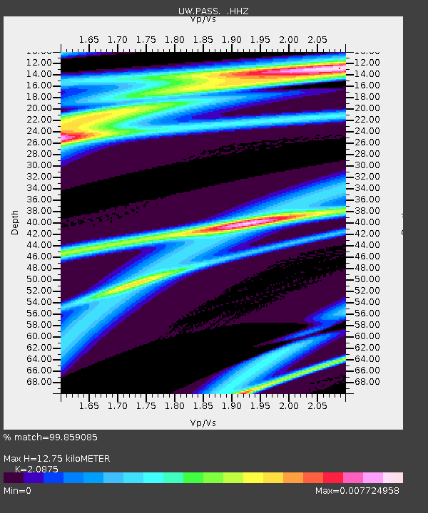
| Estimated Moho Depth: |
12.75 km |
| Estimated Crust Vp/Vs: |
2.09 |
| Assumed Crust Vp: |
6.566 km/s |
| Estimated Crust Vs: |
3.145 km/s |
| Estimated Crust Poisson's Ratio: |
0.35 |
|
| Radial Match: |
99.859085 % |
| Radial Bump: |
14 |
| Transverse Match: |
89.72135 % |
| Transverse Bump: |
212 |
| SOD ConfigId: |
512894 |
| Insert Time: |
2013-09-15 19:25:24.401 +0000 |
| GWidth: |
2.5 |
| Max Bumps: |
400 |
| Tol: |
0.001 |
|
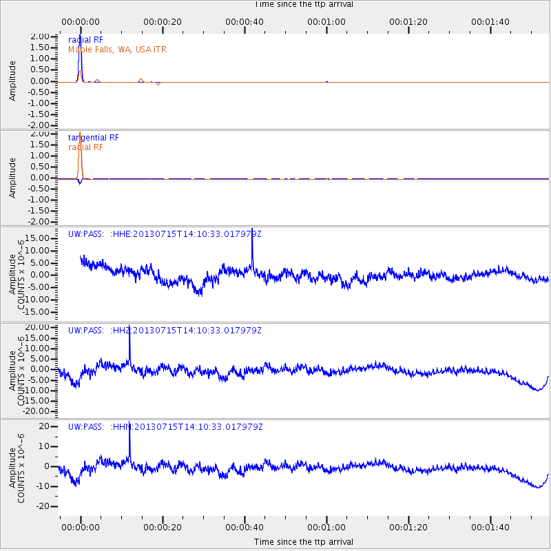
Signal To Noise
| Channel | StoN | STA | LTA |
| UW:PASS: :HHZ:20130715T14:10:33.017979Z | 1.3695753 | 3.7769087E-6 | 2.7577225E-6 |
| UW:PASS: :HHN:20130715T14:10:33.017979Z | 1.3227609 | 4.036569E-6 | 3.051624E-6 |
| UW:PASS: :HHE:20130715T14:10:33.017979Z | 1.4274607 | 4.1839266E-6 | 2.9310277E-6 |
| Arrivals |
| Ps | 2.2 SECOND |
| PpPs | 5.8 SECOND |
| PsPs/PpSs | 8.0 SECOND |


