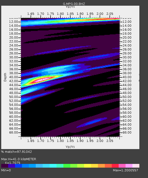
MPG Montagne des Peres, French Guyana - Earthquake Result Viewer

Earthquake location: South Sandwich Islands Region
Earthquake latitude/longitude: -60.9/-25.1
Earthquake time(UTC): 2013/07/15 (196) 14:03:39 GMT
Earthquake Depth: 11 km
Earthquake Magnitude: 7.3 MW, 6.5 MB, 7.1 MS, 7.3 MW
Earthquake Catalog/Contributor: NEIC PDE/NEIC PDE-W
Network: G GEOSCOPE
Station: MPG Montagne des Peres, French Guyana
Lat/Lon: 5.11 N/52.64 W
Elevation: 147 m
Distance: 69.2 deg
Az: 330.448 deg
Baz: 165.973 deg
Ray Param: 0.055800345
Estimated Moho Depth: 41.0 km
Estimated Crust Vp/Vs: 1.71
Assumed Crust Vp: 6.472 km/s
Estimated Crust Vs: 3.79 km/s
Estimated Crust Poisson's Ratio: 0.24
Radial Match: 97.91042 %
Radial Bump: 227
Transverse Match: 88.27253 %
Transverse Bump: 400
SOD ConfigId: 512894
Insert Time: 2013-09-15 19:29:21.991 +0000
GWidth: 2.5
Max Bumps: 400
Tol: 0.001

Signal To Noise

ChannelStoNSTALTA
G:MPG:00:BHZ:20130715T14:14:15.249995Z5.5936847.3500706E-71.3139945E-7
G:MPG:00:BHN:20130715T14:14:15.249995Z3.31330443.3135697E-71.0000801E-7
G:MPG:00:BHE:20130715T14:14:15.249995Z1.45592861.4961371E-71.0276171E-7
Arrivals
Ps4.7 SECOND
PpPs16 SECOND
PsPs/PpSs21 SECOND