You are here: Home > Network List > 7A - Mid-Atlantic Geophysical Integrative Collaboration Stations List
> Station WIRE Hazelwood, West Virginia USA > Earthquake Result Viewer
WIRE Hazelwood, West Virginia USA - Earthquake Result Viewer
| Earthquake location: |
Northern California |
| Earthquake latitude/longitude: |
38.2/-122.3 |
| Earthquake time(UTC): |
2014/08/24 (236) 10:20:44 GMT |
| Earthquake Depth: |
7.8 km |
| Earthquake Magnitude: |
6.0 MW, 6.1 MI |
| Earthquake Catalog/Contributor: |
NEIC PDE/NEIC ALERT |
|
| Network: |
7A Mid-Atlantic Geophysical Integrative Collaboration |
| Station: |
WIRE Hazelwood, West Virginia USA |
| Lat/Lon: |
38.85 N/79.84 W |
| Elevation: |
613 m |
|
| Distance: |
33.0 deg |
| Az: |
75.383 deg |
| Baz: |
282.502 deg |
| Ray Param: |
0.07840308 |
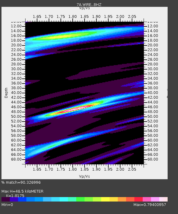
| Estimated Moho Depth: |
46.5 km |
| Estimated Crust Vp/Vs: |
1.82 |
| Assumed Crust Vp: |
6.159 km/s |
| Estimated Crust Vs: |
3.389 km/s |
| Estimated Crust Poisson's Ratio: |
0.28 |
|
| Radial Match: |
90.326996 % |
| Radial Bump: |
303 |
| Transverse Match: |
65.814766 % |
| Transverse Bump: |
400 |
| SOD ConfigId: |
3390531 |
| Insert Time: |
2019-04-13 14:12:09.740 +0000 |
| GWidth: |
2.5 |
| Max Bumps: |
400 |
| Tol: |
0.001 |
|

Signal To Noise
| Channel | StoN | STA | LTA |
| 7A:WIRE: :BHZ:20140824T10:26:48.175Z | 4.1841674 | 3.9244503E-7 | 9.379286E-8 |
| 7A:WIRE: :BHN:20140824T10:26:48.175Z | 0.90162647 | 5.8332642E-8 | 6.469713E-8 |
| 7A:WIRE: :BHE:20140824T10:26:48.175Z | 1.830322 | 1.7138666E-7 | 9.363744E-8 |
| Arrivals |
| Ps | 6.6 SECOND |
| PpPs | 20 SECOND |
| PsPs/PpSs | 26 SECOND |


