You are here: Home > Network List > PF - Volcanologic Network of Piton de Fournaise-OVPF Stations List
> Station HIM cratere Himiltrude > Earthquake Result Viewer
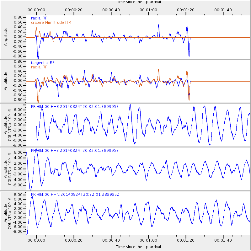
HIM cratere Himiltrude - Earthquake Result Viewer
*The percent match for this event was below the threshold and hence no stack was calculated.
| Earthquake location: |
South Sandwich Islands Region |
| Earthquake latitude/longitude: |
-55.4/-28.5 |
| Earthquake time(UTC): |
2014/08/24 (236) 20:21:24 GMT |
| Earthquake Depth: |
16 km |
| Earthquake Magnitude: |
5.5 MB |
| Earthquake Catalog/Contributor: |
NEIC PDE/NEIC COMCAT |
|
| Network: |
PF Volcanologic Network of Piton de Fournaise-OVPF |
| Station: |
HIM cratere Himiltrude |
| Lat/Lon: |
21.21 S/55.72 E |
| Elevation: |
1958 m |
|
| Distance: |
69.6 deg |
| Az: |
97.835 deg |
| Baz: |
217.276 deg |
| Ray Param: |
$rayparam |
*The percent match for this event was below the threshold and hence was not used in the summary stack. |
|
| Radial Match: |
74.781235 % |
| Radial Bump: |
400 |
| Transverse Match: |
65.14667 % |
| Transverse Bump: |
400 |
| SOD ConfigId: |
3390531 |
| Insert Time: |
2019-04-13 14:18:16.390 +0000 |
| GWidth: |
2.5 |
| Max Bumps: |
400 |
| Tol: |
0.001 |
|
Signal To Noise
| Channel | StoN | STA | LTA |
| PF:HIM:00:HHZ:20140824T20:32:01.389995Z | 1.6919092 | 4.643235E-6 | 2.744376E-6 |
| PF:HIM:00:HHN:20140824T20:32:01.389995Z | 1.0411388 | 4.0319005E-6 | 3.8725875E-6 |
| PF:HIM:00:HHE:20140824T20:32:01.389995Z | 0.89203393 | 2.7357657E-6 | 3.0668853E-6 |
| Arrivals |
| Ps | |
| PpPs | |
| PsPs/PpSs | |


