You are here: Home > Network List > CN - Canadian National Seismograph Network Stations List
> Station INK INUVIK, NT > Earthquake Result Viewer
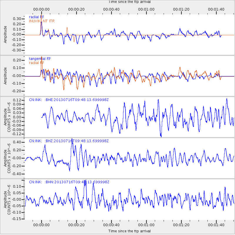
INK INUVIK, NT - Earthquake Result Viewer
*The percent match for this event was below the threshold and hence no stack was calculated.
| Earthquake location: |
Solomon Islands |
| Earthquake latitude/longitude: |
-6.3/154.8 |
| Earthquake time(UTC): |
2013/07/16 (197) 09:35:53 GMT |
| Earthquake Depth: |
40 km |
| Earthquake Magnitude: |
5.9 MW, 5.7 MS, 6.0 MW |
| Earthquake Catalog/Contributor: |
NEIC PDE/NEIC PDE-W |
|
| Network: |
CN Canadian National Seismograph Network |
| Station: |
INK INUVIK, NT |
| Lat/Lon: |
68.31 N/133.53 W |
| Elevation: |
44 m |
|
| Distance: |
89.1 deg |
| Az: |
20.673 deg |
| Baz: |
250.723 deg |
| Ray Param: |
$rayparam |
*The percent match for this event was below the threshold and hence was not used in the summary stack. |
|
| Radial Match: |
68.76861 % |
| Radial Bump: |
400 |
| Transverse Match: |
60.03301 % |
| Transverse Bump: |
400 |
| SOD ConfigId: |
512894 |
| Insert Time: |
2013-09-15 19:41:48.390 +0000 |
| GWidth: |
2.5 |
| Max Bumps: |
400 |
| Tol: |
0.001 |
|
Signal To Noise
| Channel | StoN | STA | LTA |
| CN:INK: :BHZ:20130716T09:48:13.699998Z | 3.797358 | 1.4834644E-7 | 3.90657E-8 |
| CN:INK: :BHN:20130716T09:48:13.699998Z | 0.7322349 | 1.8565066E-8 | 2.5353975E-8 |
| CN:INK: :BHE:20130716T09:48:13.699998Z | 1.4166985 | 4.1633115E-8 | 2.9387422E-8 |
| Arrivals |
| Ps | |
| PpPs | |
| PsPs/PpSs | |


