You are here: Home > Network List > TA - USArray Transportable Network (new EarthScope stations) Stations List
> Station R11A Troy Canyon, Currant, NV, USA > Earthquake Result Viewer
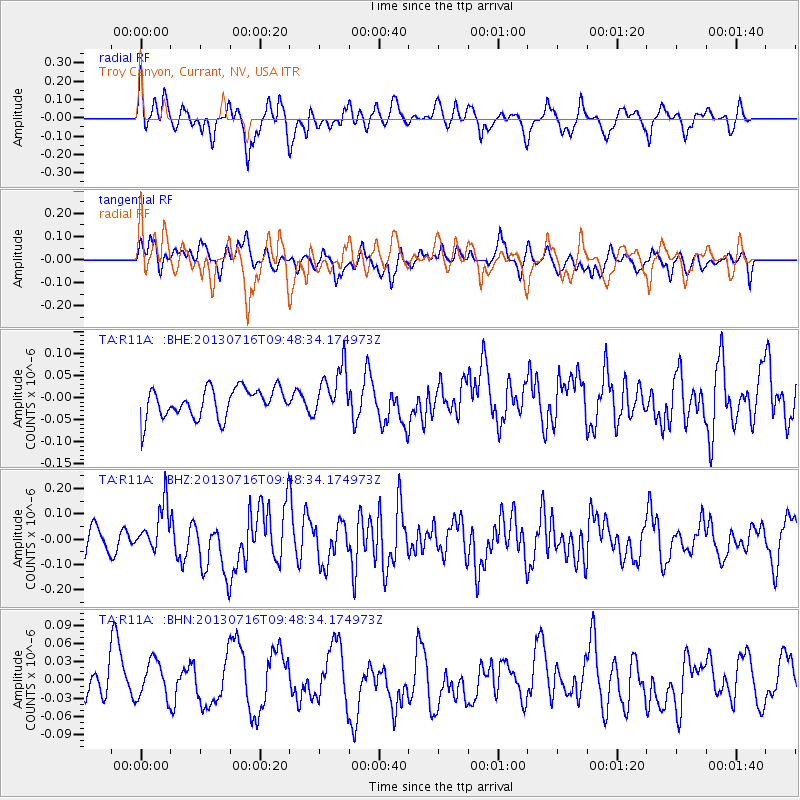
R11A Troy Canyon, Currant, NV, USA - Earthquake Result Viewer
*The percent match for this event was below the threshold and hence no stack was calculated.
| Earthquake location: |
Solomon Islands |
| Earthquake latitude/longitude: |
-6.3/154.8 |
| Earthquake time(UTC): |
2013/07/16 (197) 09:35:53 GMT |
| Earthquake Depth: |
40 km |
| Earthquake Magnitude: |
5.9 MW, 5.7 MS, 6.0 MW |
| Earthquake Catalog/Contributor: |
NEIC PDE/NEIC PDE-W |
|
| Network: |
TA USArray Transportable Network (new EarthScope stations) |
| Station: |
R11A Troy Canyon, Currant, NV, USA |
| Lat/Lon: |
38.35 N/115.59 W |
| Elevation: |
1756 m |
|
| Distance: |
93.6 deg |
| Az: |
51.979 deg |
| Baz: |
264.865 deg |
| Ray Param: |
$rayparam |
*The percent match for this event was below the threshold and hence was not used in the summary stack. |
|
| Radial Match: |
70.184875 % |
| Radial Bump: |
400 |
| Transverse Match: |
48.887726 % |
| Transverse Bump: |
400 |
| SOD ConfigId: |
512894 |
| Insert Time: |
2013-09-15 19:49:14.956 +0000 |
| GWidth: |
2.5 |
| Max Bumps: |
400 |
| Tol: |
0.001 |
|
Signal To Noise
| Channel | StoN | STA | LTA |
| TA:R11A: :BHZ:20130716T09:48:34.174973Z | 1.9230939 | 9.4308156E-8 | 4.903981E-8 |
| TA:R11A: :BHN:20130716T09:48:34.174973Z | 0.95448285 | 3.4846035E-8 | 3.6507764E-8 |
| TA:R11A: :BHE:20130716T09:48:34.174973Z | 1.6876307 | 5.6021314E-8 | 3.3195246E-8 |
| Arrivals |
| Ps | |
| PpPs | |
| PsPs/PpSs | |


