You are here: Home > Network List > AG - Arkansas Seismic Network Stations List
> Station CCAR Cane Creek, AR > Earthquake Result Viewer
CCAR Cane Creek, AR - Earthquake Result Viewer
| Earthquake location: |
Southern Peru |
| Earthquake latitude/longitude: |
-15.7/-71.7 |
| Earthquake time(UTC): |
2013/07/17 (198) 02:37:43 GMT |
| Earthquake Depth: |
7.0 km |
| Earthquake Magnitude: |
6.0 MW, 5.6 MB, 5.8 MS, 5.8 MW |
| Earthquake Catalog/Contributor: |
NEIC PDE/NEIC PDE-W |
|
| Network: |
AG Arkansas Seismic Network |
| Station: |
CCAR Cane Creek, AR |
| Lat/Lon: |
33.92 N/91.77 W |
| Elevation: |
72 m |
|
| Distance: |
52.9 deg |
| Az: |
339.065 deg |
| Baz: |
155.548 deg |
| Ray Param: |
0.06649116 |
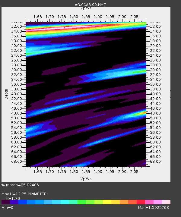
| Estimated Moho Depth: |
12.25 km |
| Estimated Crust Vp/Vs: |
1.76 |
| Assumed Crust Vp: |
6.201 km/s |
| Estimated Crust Vs: |
3.524 km/s |
| Estimated Crust Poisson's Ratio: |
0.26 |
|
| Radial Match: |
85.02405 % |
| Radial Bump: |
373 |
| Transverse Match: |
60.013012 % |
| Transverse Bump: |
400 |
| SOD ConfigId: |
512894 |
| Insert Time: |
2013-09-15 20:01:22.023 +0000 |
| GWidth: |
2.5 |
| Max Bumps: |
400 |
| Tol: |
0.001 |
|

Signal To Noise
| Channel | StoN | STA | LTA |
| AG:CCAR:00:HHZ:20130717T02:46:28.455024Z | 11.356756 | 2.0332502E-6 | 1.7903442E-7 |
| AG:CCAR:00:HHN:20130717T02:46:28.455024Z | 1.8112662 | 6.180346E-7 | 3.412169E-7 |
| AG:CCAR:00:HHE:20130717T02:46:28.455024Z | 1.7112334 | 5.752242E-7 | 3.3614597E-7 |
| Arrivals |
| Ps | 1.6 SECOND |
| PpPs | 5.2 SECOND |
| PsPs/PpSs | 6.8 SECOND |


