You are here: Home > Network List > AG - Arkansas Seismic Network Stations List
> Station LCAR Lake Charles,AR > Earthquake Result Viewer
LCAR Lake Charles,AR - Earthquake Result Viewer
| Earthquake location: |
Southern Peru |
| Earthquake latitude/longitude: |
-15.7/-71.7 |
| Earthquake time(UTC): |
2013/07/17 (198) 02:37:43 GMT |
| Earthquake Depth: |
7.0 km |
| Earthquake Magnitude: |
6.0 MW, 5.6 MB, 5.8 MS, 5.8 MW |
| Earthquake Catalog/Contributor: |
NEIC PDE/NEIC PDE-W |
|
| Network: |
AG Arkansas Seismic Network |
| Station: |
LCAR Lake Charles,AR |
| Lat/Lon: |
36.07 N/91.15 W |
| Elevation: |
103 m |
|
| Distance: |
54.6 deg |
| Az: |
340.715 deg |
| Baz: |
156.877 deg |
| Ray Param: |
0.0653369 |
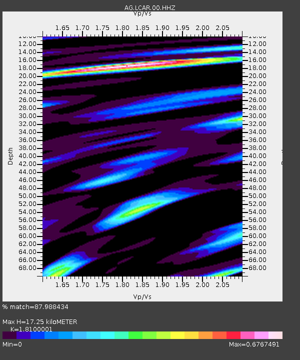
| Estimated Moho Depth: |
17.25 km |
| Estimated Crust Vp/Vs: |
1.81 |
| Assumed Crust Vp: |
6.53 km/s |
| Estimated Crust Vs: |
3.608 km/s |
| Estimated Crust Poisson's Ratio: |
0.28 |
|
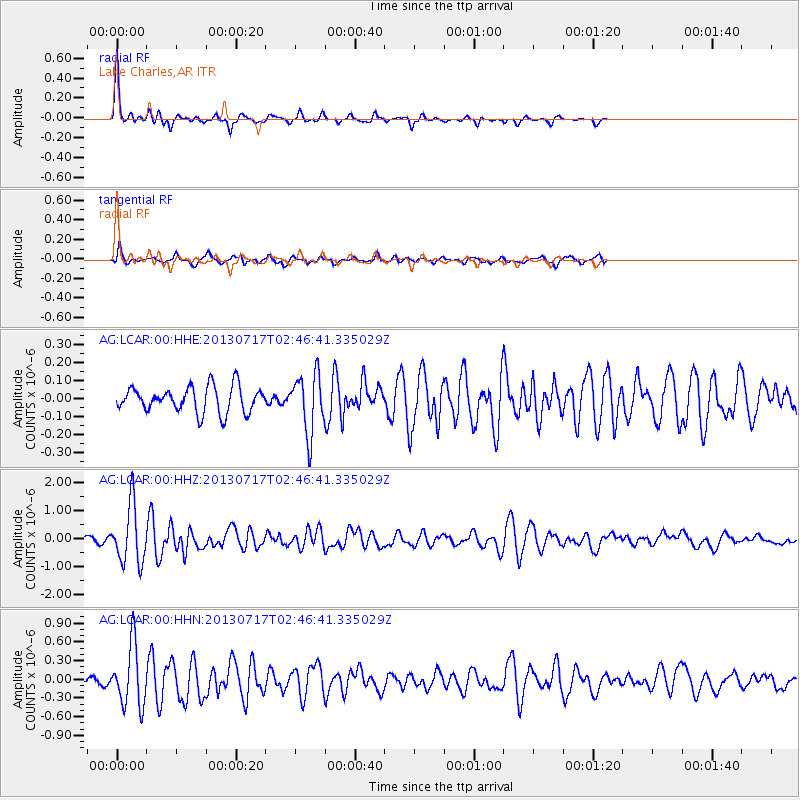
| Radial Match: |
87.988434 % |
| Radial Bump: |
274 |
| Transverse Match: |
77.442085 % |
| Transverse Bump: |
390 |
| SOD ConfigId: |
512894 |
| Insert Time: |
2013-09-15 20:01:27.532 +0000 |
| GWidth: |
2.5 |
| Max Bumps: |
400 |
| Tol: |
0.001 |
|
Signal To Noise
| Channel | StoN | STA | LTA |
| AG:LCAR:00:HHZ:20130717T02:46:41.335029Z | 14.705099 | 1.036342E-6 | 7.047501E-8 |
| AG:LCAR:00:HHN:20130717T02:46:41.335029Z | 8.987181 | 4.9101186E-7 | 5.4634697E-8 |
| AG:LCAR:00:HHE:20130717T02:46:41.335029Z | 2.3007712 | 1.6356191E-7 | 7.1090035E-8 |
| Arrivals |
| Ps | 2.3 SECOND |
| PpPs | 7.0 SECOND |
| PsPs/PpSs | 9.3 SECOND |


