You are here: Home > Network List > TA - USArray Transportable Network (new EarthScope stations) Stations List
> Station H61A Lyndonville, VT, USA > Earthquake Result Viewer
H61A Lyndonville, VT, USA - Earthquake Result Viewer
| Earthquake location: |
Iceland |
| Earthquake latitude/longitude: |
64.6/-17.3 |
| Earthquake time(UTC): |
2014/08/24 (236) 20:39:13 GMT |
| Earthquake Depth: |
13 km |
| Earthquake Magnitude: |
5.3 MW, 5.3 mb, 4.9 MS |
| Earthquake Catalog/Contributor: |
ISC/ISC |
|
| Network: |
TA USArray Transportable Network (new EarthScope stations) |
| Station: |
H61A Lyndonville, VT, USA |
| Lat/Lon: |
44.53 N/71.93 W |
| Elevation: |
462 m |
|
| Distance: |
36.0 deg |
| Az: |
263.012 deg |
| Baz: |
36.783 deg |
| Ray Param: |
0.07690861 |
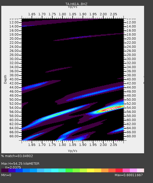
| Estimated Moho Depth: |
54.25 km |
| Estimated Crust Vp/Vs: |
2.04 |
| Assumed Crust Vp: |
6.419 km/s |
| Estimated Crust Vs: |
3.151 km/s |
| Estimated Crust Poisson's Ratio: |
0.34 |
|
| Radial Match: |
83.84902 % |
| Radial Bump: |
400 |
| Transverse Match: |
62.89726 % |
| Transverse Bump: |
400 |
| SOD ConfigId: |
3390531 |
| Insert Time: |
2019-04-13 14:25:58.305 +0000 |
| GWidth: |
2.5 |
| Max Bumps: |
400 |
| Tol: |
0.001 |
|

Signal To Noise
| Channel | StoN | STA | LTA |
| TA:H61A: :BHZ:20140824T20:45:43.024988Z | 1.8661356 | 3.05161E-7 | 1.6352563E-7 |
| TA:H61A: :BHN:20140824T20:45:43.024988Z | 0.9046145 | 1.2492973E-7 | 1.3810272E-7 |
| TA:H61A: :BHE:20140824T20:45:43.024988Z | 0.88836426 | 8.5709466E-8 | 9.648009E-8 |
| Arrivals |
| Ps | 9.4 SECOND |
| PpPs | 24 SECOND |
| PsPs/PpSs | 33 SECOND |


