You are here: Home > Network List > GS - US Geological Survey Networks Stations List
> Station ETX08 Co Rd 4789, Timpson, TX, USA > Earthquake Result Viewer
ETX08 Co Rd 4789, Timpson, TX, USA - Earthquake Result Viewer
| Earthquake location: |
Southern Peru |
| Earthquake latitude/longitude: |
-15.7/-71.7 |
| Earthquake time(UTC): |
2013/07/17 (198) 02:37:43 GMT |
| Earthquake Depth: |
7.0 km |
| Earthquake Magnitude: |
6.0 MW, 5.6 MB, 5.8 MS, 5.8 MW |
| Earthquake Catalog/Contributor: |
NEIC PDE/NEIC PDE-W |
|
| Network: |
GS US Geological Survey Networks |
| Station: |
ETX08 Co Rd 4789, Timpson, TX, USA |
| Lat/Lon: |
31.84 N/94.42 W |
| Elevation: |
107 m |
|
| Distance: |
52.0 deg |
| Az: |
335.387 deg |
| Baz: |
151.875 deg |
| Ray Param: |
0.06705604 |
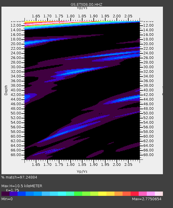
| Estimated Moho Depth: |
10.5 km |
| Estimated Crust Vp/Vs: |
1.75 |
| Assumed Crust Vp: |
5.738 km/s |
| Estimated Crust Vs: |
3.279 km/s |
| Estimated Crust Poisson's Ratio: |
0.26 |
|
| Radial Match: |
97.24884 % |
| Radial Bump: |
269 |
| Transverse Match: |
82.957756 % |
| Transverse Bump: |
400 |
| SOD ConfigId: |
512894 |
| Insert Time: |
2013-09-15 20:13:25.764 +0000 |
| GWidth: |
2.5 |
| Max Bumps: |
400 |
| Tol: |
0.001 |
|

Signal To Noise
| Channel | StoN | STA | LTA |
| GS:ETX08:00:HHZ:20130717T02:46:21.989021Z | 19.528578 | 1.0242106E-6 | 5.244676E-8 |
| GS:ETX08:00:HH1:20130717T02:46:21.989021Z | 3.621422 | 2.5212526E-7 | 6.962051E-8 |
| GS:ETX08:00:HH2:20130717T02:46:21.989021Z | 1.7486713 | 1.3898004E-7 | 7.947751E-8 |
| Arrivals |
| Ps | 1.4 SECOND |
| PpPs | 4.8 SECOND |
| PsPs/PpSs | 6.2 SECOND |


