You are here: Home > Network List > IU - Global Seismograph Network (GSN - IRIS/USGS) Stations List
> Station TEIG Tepich, Yucatan, Mexico > Earthquake Result Viewer
TEIG Tepich, Yucatan, Mexico - Earthquake Result Viewer
| Earthquake location: |
Southern Peru |
| Earthquake latitude/longitude: |
-15.7/-71.7 |
| Earthquake time(UTC): |
2013/07/17 (198) 02:37:43 GMT |
| Earthquake Depth: |
7.0 km |
| Earthquake Magnitude: |
6.0 MW, 5.6 MB, 5.8 MS, 5.8 MW |
| Earthquake Catalog/Contributor: |
NEIC PDE/NEIC PDE-W |
|
| Network: |
IU Global Seismograph Network (GSN - IRIS/USGS) |
| Station: |
TEIG Tepich, Yucatan, Mexico |
| Lat/Lon: |
20.23 N/88.28 W |
| Elevation: |
40 m |
|
| Distance: |
39.2 deg |
| Az: |
334.975 deg |
| Baz: |
154.282 deg |
| Ray Param: |
0.07513653 |
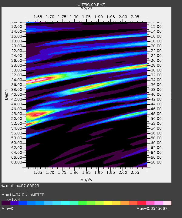
| Estimated Moho Depth: |
34.0 km |
| Estimated Crust Vp/Vs: |
1.64 |
| Assumed Crust Vp: |
5.817 km/s |
| Estimated Crust Vs: |
3.547 km/s |
| Estimated Crust Poisson's Ratio: |
0.20 |
|
| Radial Match: |
87.88829 % |
| Radial Bump: |
400 |
| Transverse Match: |
81.81831 % |
| Transverse Bump: |
400 |
| SOD ConfigId: |
512894 |
| Insert Time: |
2013-09-15 20:15:53.519 +0000 |
| GWidth: |
2.5 |
| Max Bumps: |
400 |
| Tol: |
0.001 |
|

Signal To Noise
| Channel | StoN | STA | LTA |
| IU:TEIG:00:BHZ:20130717T02:44:40.847999Z | 12.530026 | 1.6229718E-6 | 1.2952661E-7 |
| IU:TEIG:00:BH1:20130717T02:44:40.847999Z | 1.3731849 | 7.9762074E-8 | 5.8085458E-8 |
| IU:TEIG:00:BH2:20130717T02:44:40.847999Z | 6.9655743 | 9.828598E-7 | 1.4110248E-7 |
| Arrivals |
| Ps | 4.0 SECOND |
| PpPs | 14 SECOND |
| PsPs/PpSs | 18 SECOND |


