You are here: Home > Network List > LD - Lamont-Doherty Cooperative Seismographic Network Stations List
> Station BRNJ Basking Ridge, New Jersey > Earthquake Result Viewer
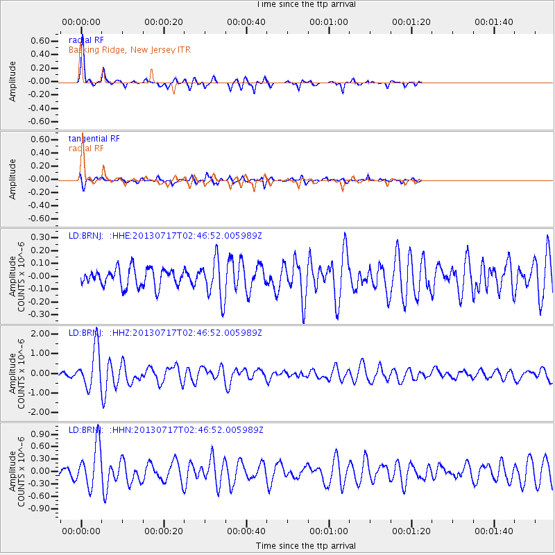
BRNJ Basking Ridge, New Jersey - Earthquake Result Viewer

| Earthquake location: |
Southern Peru |
| Earthquake latitude/longitude: |
-15.7/-71.7 |
| Earthquake time(UTC): |
2013/07/17 (198) 02:37:43 GMT |
| Earthquake Depth: |
7.0 km |
| Earthquake Magnitude: |
6.0 MW, 5.6 MB, 5.8 MS, 5.8 MW |
| Earthquake Catalog/Contributor: |
NEIC PDE/NEIC PDE-W |
|
| Network: |
LD Lamont-Doherty Cooperative Seismographic Network |
| Station: |
BRNJ Basking Ridge, New Jersey |
| Lat/Lon: |
40.68 N/74.57 W |
| Elevation: |
50 m |
|
| Distance: |
56.1 deg |
| Az: |
357.411 deg |
| Baz: |
176.72 deg |
| Ray Param: |
0.064361736 |
| Estimated Moho Depth: |
34.75 km |
| Estimated Crust Vp/Vs: |
1.96 |
| Assumed Crust Vp: |
6.283 km/s |
| Estimated Crust Vs: |
3.214 km/s |
| Estimated Crust Poisson's Ratio: |
0.32 |
|
| Radial Match: |
83.138695 % |
| Radial Bump: |
226 |
| Transverse Match: |
72.29936 % |
| Transverse Bump: |
400 |
| SOD ConfigId: |
512894 |
| Insert Time: |
2013-09-15 20:17:04.898 +0000 |
| GWidth: |
2.5 |
| Max Bumps: |
400 |
| Tol: |
0.001 |
|
Signal To Noise
| Channel | StoN | STA | LTA |
| LD:BRNJ: :HHZ:20130717T02:46:52.005989Z | 10.032549 | 1.0376328E-6 | 1.0342664E-7 |
| LD:BRNJ: :HHN:20130717T02:46:52.005989Z | 4.1813745 | 5.282771E-7 | 1.2634054E-7 |
| LD:BRNJ: :HHE:20130717T02:46:52.005989Z | 2.3561528 | 1.6027653E-7 | 6.8024676E-8 |
| Arrivals |
| Ps | 5.5 SECOND |
| PpPs | 16 SECOND |
| PsPs/PpSs | 21 SECOND |


