You are here: Home > Network List > NE - New England Seismic Network Stations List
> Station HNH Hanover, NH, USA > Earthquake Result Viewer
HNH Hanover, NH, USA - Earthquake Result Viewer
| Earthquake location: |
Southern Peru |
| Earthquake latitude/longitude: |
-15.7/-71.7 |
| Earthquake time(UTC): |
2013/07/17 (198) 02:37:43 GMT |
| Earthquake Depth: |
7.0 km |
| Earthquake Magnitude: |
6.0 MW, 5.6 MB, 5.8 MS, 5.8 MW |
| Earthquake Catalog/Contributor: |
NEIC PDE/NEIC PDE-W |
|
| Network: |
NE New England Seismic Network |
| Station: |
HNH Hanover, NH, USA |
| Lat/Lon: |
43.71 N/72.29 W |
| Elevation: |
180 m |
|
| Distance: |
59.1 deg |
| Az: |
359.538 deg |
| Baz: |
179.386 deg |
| Ray Param: |
0.06243738 |
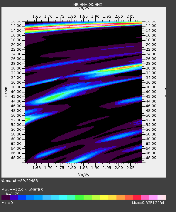
| Estimated Moho Depth: |
12.0 km |
| Estimated Crust Vp/Vs: |
1.79 |
| Assumed Crust Vp: |
6.419 km/s |
| Estimated Crust Vs: |
3.586 km/s |
| Estimated Crust Poisson's Ratio: |
0.27 |
|
| Radial Match: |
89.22488 % |
| Radial Bump: |
320 |
| Transverse Match: |
81.31175 % |
| Transverse Bump: |
320 |
| SOD ConfigId: |
512894 |
| Insert Time: |
2013-09-15 20:19:17.331 +0000 |
| GWidth: |
2.5 |
| Max Bumps: |
400 |
| Tol: |
0.001 |
|

Signal To Noise
| Channel | StoN | STA | LTA |
| NE:HNH:00:HHZ:20130717T02:47:12.818977Z | 8.531087 | 9.899231E-7 | 1.16037164E-7 |
| NE:HNH:00:HH1:20130717T02:47:12.818977Z | 5.8332405 | 4.6166474E-7 | 7.914379E-8 |
| NE:HNH:00:HH2:20130717T02:47:12.818977Z | 2.931932 | 3.3913233E-7 | 1.15668556E-7 |
| Arrivals |
| Ps | 1.5 SECOND |
| PpPs | 5.0 SECOND |
| PsPs/PpSs | 6.5 SECOND |


