You are here: Home > Network List > WU - The Southern Ontario Seismic Network Stations List
> Station DELO Deloro Mine, Ontario, Canada > Earthquake Result Viewer
DELO Deloro Mine, Ontario, Canada - Earthquake Result Viewer
| Earthquake location: |
Iceland |
| Earthquake latitude/longitude: |
64.6/-17.3 |
| Earthquake time(UTC): |
2014/08/24 (236) 20:39:13 GMT |
| Earthquake Depth: |
13 km |
| Earthquake Magnitude: |
5.3 MW, 5.3 mb, 4.9 MS |
| Earthquake Catalog/Contributor: |
ISC/ISC |
|
| Network: |
WU The Southern Ontario Seismic Network |
| Station: |
DELO Deloro Mine, Ontario, Canada |
| Lat/Lon: |
44.52 N/77.62 W |
| Elevation: |
213 m |
|
| Distance: |
38.5 deg |
| Az: |
268.374 deg |
| Baz: |
37.075 deg |
| Ray Param: |
0.075537615 |
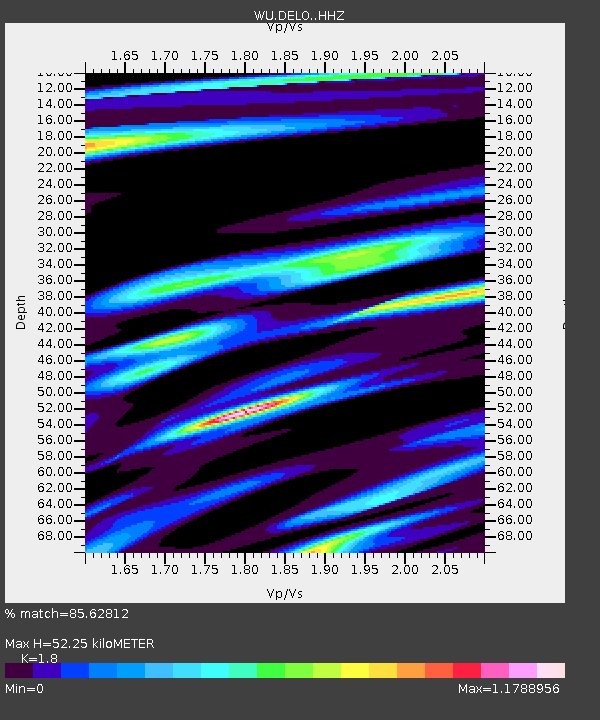
| Estimated Moho Depth: |
52.25 km |
| Estimated Crust Vp/Vs: |
1.80 |
| Assumed Crust Vp: |
6.577 km/s |
| Estimated Crust Vs: |
3.654 km/s |
| Estimated Crust Poisson's Ratio: |
0.28 |
|
| Radial Match: |
85.62812 % |
| Radial Bump: |
400 |
| Transverse Match: |
57.867615 % |
| Transverse Bump: |
400 |
| SOD ConfigId: |
3390531 |
| Insert Time: |
2019-04-13 14:27:44.646 +0000 |
| GWidth: |
2.5 |
| Max Bumps: |
400 |
| Tol: |
0.001 |
|

Signal To Noise
| Channel | StoN | STA | LTA |
| WU:DELO: :HHZ:20140824T20:46:03.800012Z | 1.1046176 | 1.08333545E-7 | 9.807334E-8 |
| WU:DELO: :HHN:20140824T20:46:03.800012Z | 0.67664486 | 9.590816E-8 | 1.4174077E-7 |
| WU:DELO: :HHE:20140824T20:46:03.800012Z | 1.0508225 | 8.1736665E-8 | 7.778351E-8 |
| Arrivals |
| Ps | 6.8 SECOND |
| PpPs | 21 SECOND |
| PsPs/PpSs | 27 SECOND |


