You are here: Home > Network List > PO - Portable Observatories for Lithospheric Analysis and Research Investigating Seis Stations List
> Station BANO BANCROFT, ON > Earthquake Result Viewer
BANO BANCROFT, ON - Earthquake Result Viewer
| Earthquake location: |
Southern Peru |
| Earthquake latitude/longitude: |
-15.7/-71.7 |
| Earthquake time(UTC): |
2013/07/17 (198) 02:37:43 GMT |
| Earthquake Depth: |
7.0 km |
| Earthquake Magnitude: |
6.0 MW, 5.6 MB, 5.8 MS, 5.8 MW |
| Earthquake Catalog/Contributor: |
NEIC PDE/NEIC PDE-W |
|
| Network: |
PO Portable Observatories for Lithospheric Analysis and Research Investigating Seis |
| Station: |
BANO BANCROFT, ON |
| Lat/Lon: |
45.02 N/77.93 W |
| Elevation: |
360 m |
|
| Distance: |
60.6 deg |
| Az: |
354.968 deg |
| Baz: |
173.158 deg |
| Ray Param: |
0.0614013 |
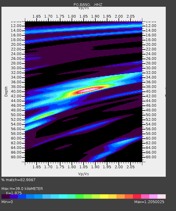
| Estimated Moho Depth: |
39.0 km |
| Estimated Crust Vp/Vs: |
1.88 |
| Assumed Crust Vp: |
6.577 km/s |
| Estimated Crust Vs: |
3.508 km/s |
| Estimated Crust Poisson's Ratio: |
0.30 |
|
| Radial Match: |
82.9867 % |
| Radial Bump: |
384 |
| Transverse Match: |
59.508686 % |
| Transverse Bump: |
400 |
| SOD ConfigId: |
512894 |
| Insert Time: |
2013-09-15 20:24:04.544 +0000 |
| GWidth: |
2.5 |
| Max Bumps: |
400 |
| Tol: |
0.001 |
|

Signal To Noise
| Channel | StoN | STA | LTA |
| PO:BANO: :HHZ:20130717T02:47:23.620002Z | 5.299408 | 5.7660657E-7 | 1.0880584E-7 |
| PO:BANO: :HHN:20130717T02:47:23.620002Z | 4.474876 | 3.4249018E-7 | 7.653624E-8 |
| PO:BANO: :HHE:20130717T02:47:23.620002Z | 0.7906983 | 3.8710635E-8 | 4.895753E-8 |
| Arrivals |
| Ps | 5.4 SECOND |
| PpPs | 16 SECOND |
| PsPs/PpSs | 22 SECOND |


