You are here: Home > Network List > PO - Portable Observatories for Lithospheric Analysis and Research Investigating Seis Stations List
> Station BRCO BRUCE PENN., ON > Earthquake Result Viewer
BRCO BRUCE PENN., ON - Earthquake Result Viewer
| Earthquake location: |
Southern Peru |
| Earthquake latitude/longitude: |
-15.7/-71.7 |
| Earthquake time(UTC): |
2013/07/17 (198) 02:37:43 GMT |
| Earthquake Depth: |
7.0 km |
| Earthquake Magnitude: |
6.0 MW, 5.6 MB, 5.8 MS, 5.8 MW |
| Earthquake Catalog/Contributor: |
NEIC PDE/NEIC PDE-W |
|
| Network: |
PO Portable Observatories for Lithospheric Analysis and Research Investigating Seis |
| Station: |
BRCO BRUCE PENN., ON |
| Lat/Lon: |
44.24 N/81.44 W |
| Elevation: |
273 m |
|
| Distance: |
60.3 deg |
| Az: |
351.982 deg |
| Baz: |
169.224 deg |
| Ray Param: |
0.061654195 |
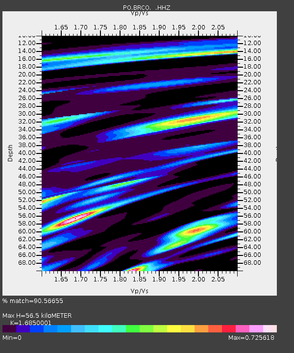
| Estimated Moho Depth: |
56.5 km |
| Estimated Crust Vp/Vs: |
1.69 |
| Assumed Crust Vp: |
6.53 km/s |
| Estimated Crust Vs: |
3.876 km/s |
| Estimated Crust Poisson's Ratio: |
0.23 |
|
| Radial Match: |
90.56655 % |
| Radial Bump: |
304 |
| Transverse Match: |
54.045044 % |
| Transverse Bump: |
400 |
| SOD ConfigId: |
512894 |
| Insert Time: |
2013-09-15 20:24:10.834 +0000 |
| GWidth: |
2.5 |
| Max Bumps: |
400 |
| Tol: |
0.001 |
|

Signal To Noise
| Channel | StoN | STA | LTA |
| PO:BRCO: :HHZ:20130717T02:47:21.010017Z | 5.27521 | 6.491278E-7 | 1.2305252E-7 |
| PO:BRCO: :HHN:20130717T02:47:21.010017Z | 4.1338973 | 3.8390166E-7 | 9.286676E-8 |
| PO:BRCO: :HHE:20130717T02:47:21.010017Z | 0.5250269 | 7.393814E-8 | 1.4082734E-7 |
| Arrivals |
| Ps | 6.2 SECOND |
| PpPs | 22 SECOND |
| PsPs/PpSs | 28 SECOND |


