You are here: Home > Network List > UW - Pacific Northwest Regional Seismic Network Stations List
> Station TAKO Tahkenitch, OR CREST BB SMO > Earthquake Result Viewer
TAKO Tahkenitch, OR CREST BB SMO - Earthquake Result Viewer

| Earthquake location: |
Southern Peru |
| Earthquake latitude/longitude: |
-16.1/-71.8 |
| Earthquake time(UTC): |
2006/11/27 (331) 17:31:48 GMT |
| Earthquake Depth: |
116 km |
| Earthquake Magnitude: |
5.3 MB, 5.7 MW, 5.6 MW |
| Earthquake Catalog/Contributor: |
WHDF/NEIC |
|
| Network: |
UW Pacific Northwest Regional Seismic Network |
| Station: |
TAKO Tahkenitch, OR CREST BB SMO |
| Lat/Lon: |
43.74 N/124.08 W |
| Elevation: |
46 m |
|
| Distance: |
76.3 deg |
| Az: |
323.835 deg |
| Baz: |
128.477 deg |
| Ray Param: |
0.050817825 |
| Estimated Moho Depth: |
61.0 km |
| Estimated Crust Vp/Vs: |
1.88 |
| Assumed Crust Vp: |
6.048 km/s |
| Estimated Crust Vs: |
3.221 km/s |
| Estimated Crust Poisson's Ratio: |
0.30 |
|
| Radial Match: |
84.79712 % |
| Radial Bump: |
400 |
| Transverse Match: |
56.36912 % |
| Transverse Bump: |
395 |
| SOD ConfigId: |
2564 |
| Insert Time: |
2010-02-27 05:04:47.793 +0000 |
| GWidth: |
2.5 |
| Max Bumps: |
400 |
| Tol: |
0.001 |
|
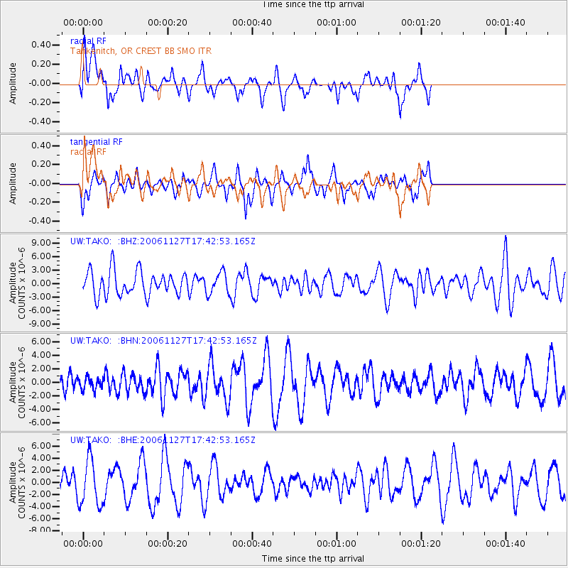
Signal To Noise
| Channel | StoN | STA | LTA |
| UW:TAKO: :BHN:20061127T17:42:53.165Z | 0.49270645 | 9.1686553E-7 | 1.8608758E-6 |
| UW:TAKO: :BHE:20061127T17:42:53.165Z | 2.1579504 | 3.7880347E-6 | 1.7553856E-6 |
| UW:TAKO: :BHZ:20061127T17:42:53.165Z | 0.9096378 | 2.4315732E-6 | 2.6731223E-6 |
| Arrivals |
| Ps | 9.1 SECOND |
| PpPs | 28 SECOND |
| PsPs/PpSs | 37 SECOND |


