You are here: Home > Network List > TA - USArray Transportable Network (new EarthScope stations) Stations List
> Station 149A Jones, AL, USA > Earthquake Result Viewer
149A Jones, AL, USA - Earthquake Result Viewer

| Earthquake location: |
Southern Peru |
| Earthquake latitude/longitude: |
-15.7/-71.7 |
| Earthquake time(UTC): |
2013/07/17 (198) 02:37:43 GMT |
| Earthquake Depth: |
7.0 km |
| Earthquake Magnitude: |
6.0 MW, 5.6 MB, 5.8 MS, 5.8 MW |
| Earthquake Catalog/Contributor: |
NEIC PDE/NEIC PDE-W |
|
| Network: |
TA USArray Transportable Network (new EarthScope stations) |
| Station: |
149A Jones, AL, USA |
| Lat/Lon: |
32.60 N/86.79 W |
| Elevation: |
138 m |
|
| Distance: |
50.1 deg |
| Az: |
343.397 deg |
| Baz: |
160.967 deg |
| Ray Param: |
0.06828825 |
| Estimated Moho Depth: |
48.75 km |
| Estimated Crust Vp/Vs: |
1.70 |
| Assumed Crust Vp: |
6.565 km/s |
| Estimated Crust Vs: |
3.867 km/s |
| Estimated Crust Poisson's Ratio: |
0.23 |
|
| Radial Match: |
84.13787 % |
| Radial Bump: |
400 |
| Transverse Match: |
67.669365 % |
| Transverse Bump: |
400 |
| SOD ConfigId: |
512894 |
| Insert Time: |
2013-09-15 20:27:47.191 +0000 |
| GWidth: |
2.5 |
| Max Bumps: |
400 |
| Tol: |
0.001 |
|
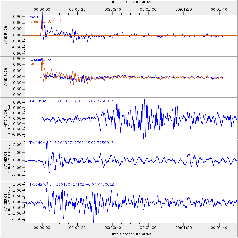
Signal To Noise
| Channel | StoN | STA | LTA |
| TA:149A: :BHZ:20130717T02:46:07.775001Z | 17.85933 | 1.1059292E-6 | 6.192445E-8 |
| TA:149A: :BHN:20130717T02:46:07.775001Z | 8.009889 | 6.858509E-7 | 8.562553E-8 |
| TA:149A: :BHE:20130717T02:46:07.775001Z | 3.4527047 | 2.8255087E-7 | 8.183465E-8 |
| Arrivals |
| Ps | 5.5 SECOND |
| PpPs | 19 SECOND |
| PsPs/PpSs | 24 SECOND |


