You are here: Home > Network List > TA - USArray Transportable Network (new EarthScope stations) Stations List
> Station 155A Kite, GA, USA > Earthquake Result Viewer
155A Kite, GA, USA - Earthquake Result Viewer
| Earthquake location: |
Southern Peru |
| Earthquake latitude/longitude: |
-15.7/-71.7 |
| Earthquake time(UTC): |
2013/07/17 (198) 02:37:43 GMT |
| Earthquake Depth: |
7.0 km |
| Earthquake Magnitude: |
6.0 MW, 5.6 MB, 5.8 MS, 5.8 MW |
| Earthquake Catalog/Contributor: |
NEIC PDE/NEIC PDE-W |
|
| Network: |
TA USArray Transportable Network (new EarthScope stations) |
| Station: |
155A Kite, GA, USA |
| Lat/Lon: |
32.62 N/82.47 W |
| Elevation: |
93 m |
|
| Distance: |
49.1 deg |
| Az: |
348.005 deg |
| Baz: |
166.276 deg |
| Ray Param: |
0.06893364 |
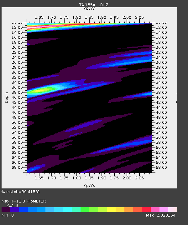
| Estimated Moho Depth: |
12.0 km |
| Estimated Crust Vp/Vs: |
1.60 |
| Assumed Crust Vp: |
6.565 km/s |
| Estimated Crust Vs: |
4.103 km/s |
| Estimated Crust Poisson's Ratio: |
0.18 |
|
| Radial Match: |
90.41581 % |
| Radial Bump: |
333 |
| Transverse Match: |
83.44802 % |
| Transverse Bump: |
325 |
| SOD ConfigId: |
512894 |
| Insert Time: |
2013-09-15 20:28:03.956 +0000 |
| GWidth: |
2.5 |
| Max Bumps: |
400 |
| Tol: |
0.001 |
|
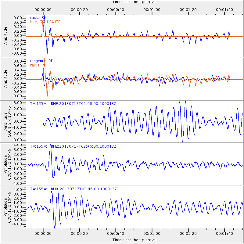
Signal To Noise
| Channel | StoN | STA | LTA |
| TA:155A: :BHZ:20130717T02:46:00.100013Z | 9.708035 | 1.619982E-6 | 1.6687021E-7 |
| TA:155A: :BHN:20130717T02:46:00.100013Z | 2.6117158 | 1.2823023E-6 | 4.9098077E-7 |
| TA:155A: :BHE:20130717T02:46:00.100013Z | 0.932114 | 5.470831E-7 | 5.8692723E-7 |
| Arrivals |
| Ps | 1.2 SECOND |
| PpPs | 4.4 SECOND |
| PsPs/PpSs | 5.6 SECOND |


