You are here: Home > Network List > AE - Arizona Broadband Seismic Network Stations List
> Station X16A Lo Mia Camp, Pine, AZ, USA > Earthquake Result Viewer
X16A Lo Mia Camp, Pine, AZ, USA - Earthquake Result Viewer
| Earthquake location: |
Central Peru |
| Earthquake latitude/longitude: |
-14.6/-73.6 |
| Earthquake time(UTC): |
2014/08/24 (236) 23:21:45 GMT |
| Earthquake Depth: |
101 km |
| Earthquake Magnitude: |
6.9 MWW, 6.8 MI, 6.9 MWB |
| Earthquake Catalog/Contributor: |
NEIC PDE/NEIC COMCAT |
|
| Network: |
AE Arizona Broadband Seismic Network |
| Station: |
X16A Lo Mia Camp, Pine, AZ, USA |
| Lat/Lon: |
34.42 N/111.44 W |
| Elevation: |
1759 m |
|
| Distance: |
60.6 deg |
| Az: |
324.374 deg |
| Baz: |
136.986 deg |
| Ray Param: |
0.061144322 |
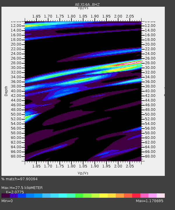
| Estimated Moho Depth: |
27.5 km |
| Estimated Crust Vp/Vs: |
2.08 |
| Assumed Crust Vp: |
6.207 km/s |
| Estimated Crust Vs: |
2.988 km/s |
| Estimated Crust Poisson's Ratio: |
0.35 |
|
| Radial Match: |
97.90094 % |
| Radial Bump: |
323 |
| Transverse Match: |
87.3025 % |
| Transverse Bump: |
400 |
| SOD ConfigId: |
3390531 |
| Insert Time: |
2019-04-13 14:30:48.528 +0000 |
| GWidth: |
2.5 |
| Max Bumps: |
400 |
| Tol: |
0.001 |
|

Signal To Noise
| Channel | StoN | STA | LTA |
| AE:X16A: :BHZ:20140824T23:31:14.12502Z | 36.578255 | 5.369934E-6 | 1.4680673E-7 |
| AE:X16A: :BHN:20140824T23:31:14.12502Z | 15.263962 | 2.0049379E-6 | 1.3135109E-7 |
| AE:X16A: :BHE:20140824T23:31:14.12502Z | 13.781373 | 1.5604211E-6 | 1.13226825E-7 |
| Arrivals |
| Ps | 5.0 SECOND |
| PpPs | 13 SECOND |
| PsPs/PpSs | 18 SECOND |


