You are here: Home > Network List > TA - USArray Transportable Network (new EarthScope stations) Stations List
> Station 250A Grady, AL, USA > Earthquake Result Viewer
250A Grady, AL, USA - Earthquake Result Viewer

| Earthquake location: |
Southern Peru |
| Earthquake latitude/longitude: |
-15.7/-71.7 |
| Earthquake time(UTC): |
2013/07/17 (198) 02:37:43 GMT |
| Earthquake Depth: |
7.0 km |
| Earthquake Magnitude: |
6.0 MW, 5.6 MB, 5.8 MS, 5.8 MW |
| Earthquake Catalog/Contributor: |
NEIC PDE/NEIC PDE-W |
|
| Network: |
TA USArray Transportable Network (new EarthScope stations) |
| Station: |
250A Grady, AL, USA |
| Lat/Lon: |
31.98 N/86.27 W |
| Elevation: |
152 m |
|
| Distance: |
49.4 deg |
| Az: |
343.686 deg |
| Baz: |
161.432 deg |
| Ray Param: |
0.068751544 |
| Estimated Moho Depth: |
65.25 km |
| Estimated Crust Vp/Vs: |
1.92 |
| Assumed Crust Vp: |
6.187 km/s |
| Estimated Crust Vs: |
3.214 km/s |
| Estimated Crust Poisson's Ratio: |
0.32 |
|
| Radial Match: |
82.06524 % |
| Radial Bump: |
337 |
| Transverse Match: |
75.50369 % |
| Transverse Bump: |
352 |
| SOD ConfigId: |
512894 |
| Insert Time: |
2013-09-15 20:28:21.114 +0000 |
| GWidth: |
2.5 |
| Max Bumps: |
400 |
| Tol: |
0.001 |
|
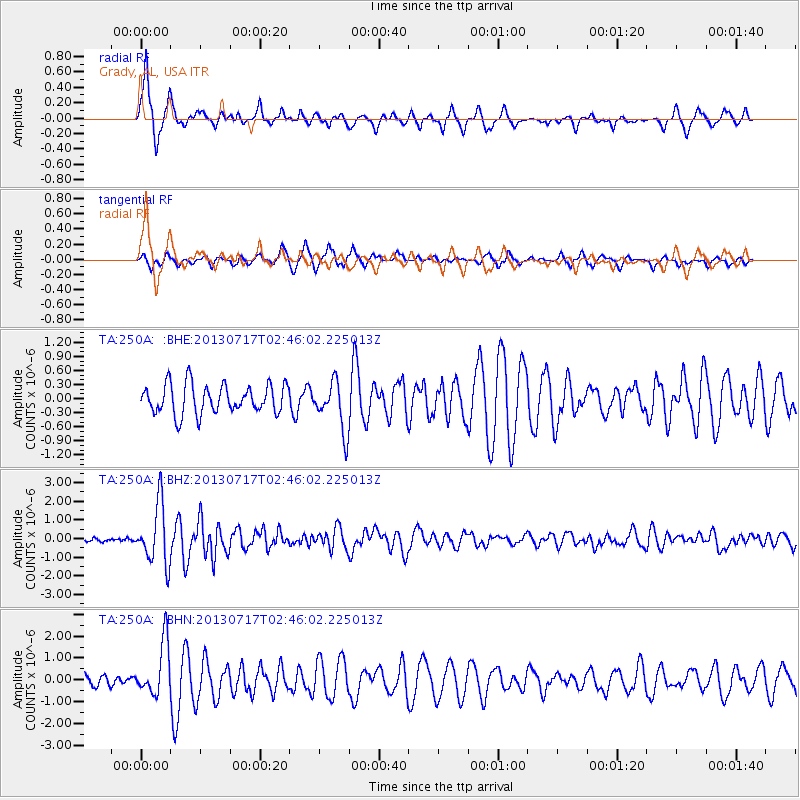
Signal To Noise
| Channel | StoN | STA | LTA |
| TA:250A: :BHZ:20130717T02:46:02.225013Z | 10.511268 | 1.6049186E-6 | 1.5268554E-7 |
| TA:250A: :BHN:20130717T02:46:02.225013Z | 4.276628 | 1.2096446E-6 | 2.828501E-7 |
| TA:250A: :BHE:20130717T02:46:02.225013Z | 1.6994303 | 5.265998E-7 | 3.0986845E-7 |
| Arrivals |
| Ps | 10 SECOND |
| PpPs | 29 SECOND |
| PsPs/PpSs | 40 SECOND |


