You are here: Home > Network List > TA - USArray Transportable Network (new EarthScope stations) Stations List
> Station 251A Midway, AL, USA > Earthquake Result Viewer
251A Midway, AL, USA - Earthquake Result Viewer

| Earthquake location: |
Southern Peru |
| Earthquake latitude/longitude: |
-15.7/-71.7 |
| Earthquake time(UTC): |
2013/07/17 (198) 02:37:43 GMT |
| Earthquake Depth: |
7.0 km |
| Earthquake Magnitude: |
6.0 MW, 5.6 MB, 5.8 MS, 5.8 MW |
| Earthquake Catalog/Contributor: |
NEIC PDE/NEIC PDE-W |
|
| Network: |
TA USArray Transportable Network (new EarthScope stations) |
| Station: |
251A Midway, AL, USA |
| Lat/Lon: |
32.09 N/85.41 W |
| Elevation: |
139 m |
|
| Distance: |
49.3 deg |
| Az: |
344.647 deg |
| Baz: |
162.513 deg |
| Ray Param: |
0.06882567 |
| Estimated Moho Depth: |
36.25 km |
| Estimated Crust Vp/Vs: |
1.66 |
| Assumed Crust Vp: |
6.719 km/s |
| Estimated Crust Vs: |
4.054 km/s |
| Estimated Crust Poisson's Ratio: |
0.21 |
|
| Radial Match: |
95.545166 % |
| Radial Bump: |
304 |
| Transverse Match: |
82.84695 % |
| Transverse Bump: |
400 |
| SOD ConfigId: |
512894 |
| Insert Time: |
2013-09-15 20:28:25.686 +0000 |
| GWidth: |
2.5 |
| Max Bumps: |
400 |
| Tol: |
0.001 |
|
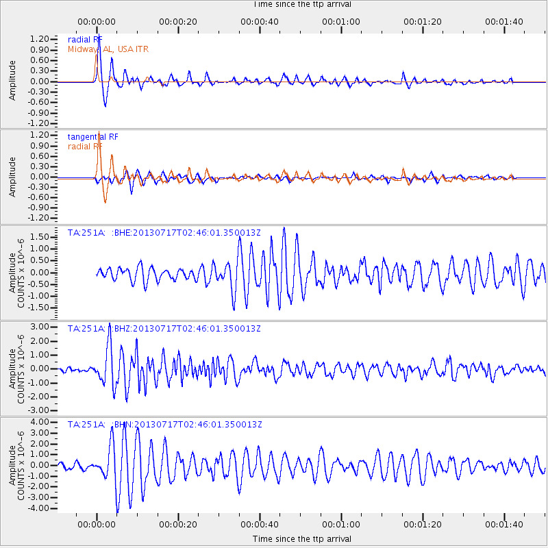
Signal To Noise
| Channel | StoN | STA | LTA |
| TA:251A: :BHZ:20130717T02:46:01.350013Z | 10.935902 | 1.4167213E-6 | 1.2954774E-7 |
| TA:251A: :BHN:20130717T02:46:01.350013Z | 6.2393847 | 1.5716333E-6 | 2.5188916E-7 |
| TA:251A: :BHE:20130717T02:46:01.350013Z | 2.4464738 | 6.140521E-7 | 2.5099476E-7 |
| Arrivals |
| Ps | 3.8 SECOND |
| PpPs | 13 SECOND |
| PsPs/PpSs | 17 SECOND |


