You are here: Home > Network List > TA - USArray Transportable Network (new EarthScope stations) Stations List
> Station 252A Lumpkin, GA, USA > Earthquake Result Viewer
252A Lumpkin, GA, USA - Earthquake Result Viewer

| Earthquake location: |
Southern Peru |
| Earthquake latitude/longitude: |
-15.7/-71.7 |
| Earthquake time(UTC): |
2013/07/17 (198) 02:37:43 GMT |
| Earthquake Depth: |
7.0 km |
| Earthquake Magnitude: |
6.0 MW, 5.6 MB, 5.8 MS, 5.8 MW |
| Earthquake Catalog/Contributor: |
NEIC PDE/NEIC PDE-W |
|
| Network: |
TA USArray Transportable Network (new EarthScope stations) |
| Station: |
252A Lumpkin, GA, USA |
| Lat/Lon: |
32.00 N/84.74 W |
| Elevation: |
142 m |
|
| Distance: |
49.0 deg |
| Az: |
345.333 deg |
| Baz: |
163.317 deg |
| Ray Param: |
0.06899925 |
| Estimated Moho Depth: |
14.0 km |
| Estimated Crust Vp/Vs: |
1.68 |
| Assumed Crust Vp: |
6.347 km/s |
| Estimated Crust Vs: |
3.778 km/s |
| Estimated Crust Poisson's Ratio: |
0.23 |
|
| Radial Match: |
80.13584 % |
| Radial Bump: |
346 |
| Transverse Match: |
64.07822 % |
| Transverse Bump: |
395 |
| SOD ConfigId: |
512894 |
| Insert Time: |
2013-09-15 20:28:26.314 +0000 |
| GWidth: |
2.5 |
| Max Bumps: |
400 |
| Tol: |
0.001 |
|
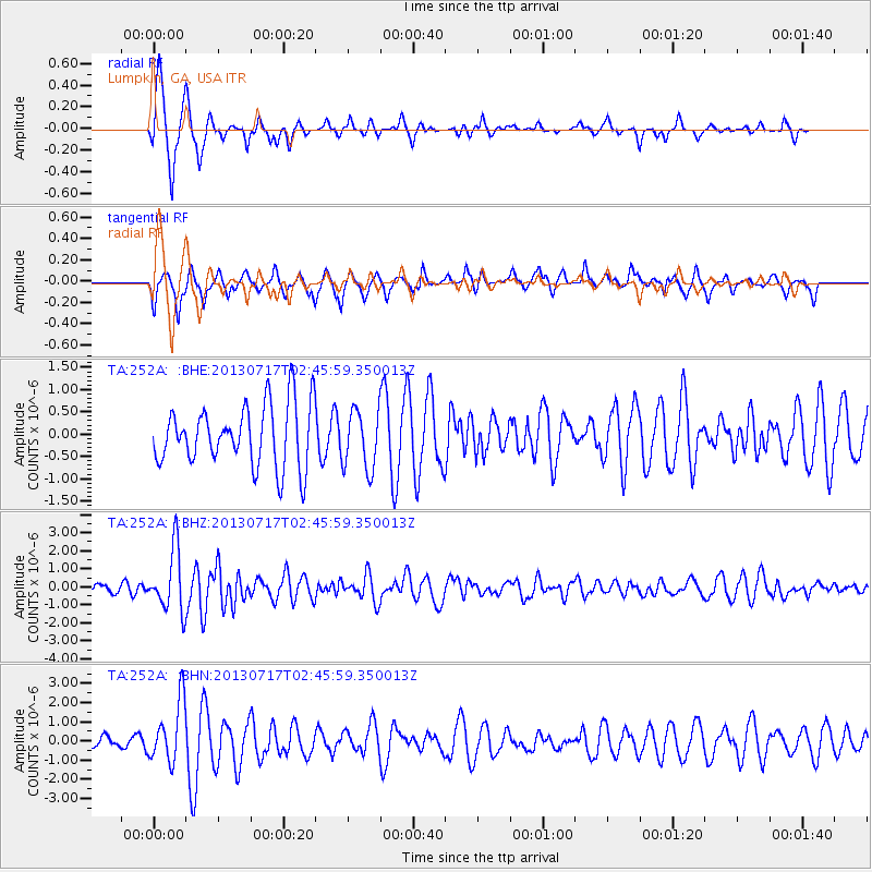
Signal To Noise
| Channel | StoN | STA | LTA |
| TA:252A: :BHZ:20130717T02:45:59.350013Z | 6.808551 | 1.7109828E-6 | 2.512991E-7 |
| TA:252A: :BHN:20130717T02:45:59.350013Z | 3.1159356 | 1.5747144E-6 | 5.053745E-7 |
| TA:252A: :BHE:20130717T02:45:59.350013Z | 0.95887434 | 6.628902E-7 | 6.9132125E-7 |
| Arrivals |
| Ps | 1.6 SECOND |
| PpPs | 5.6 SECOND |
| PsPs/PpSs | 7.2 SECOND |


