You are here: Home > Network List > TA - USArray Transportable Network (new EarthScope stations) Stations List
> Station 254A Abbeville, GA, USA > Earthquake Result Viewer
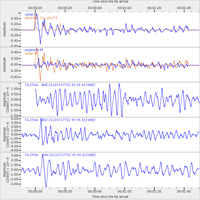
254A Abbeville, GA, USA - Earthquake Result Viewer
*The percent match for this event was below the threshold and hence no stack was calculated.
| Earthquake location: |
Southern Peru |
| Earthquake latitude/longitude: |
-15.7/-71.7 |
| Earthquake time(UTC): |
2013/07/17 (198) 02:37:43 GMT |
| Earthquake Depth: |
7.0 km |
| Earthquake Magnitude: |
6.0 MW, 5.6 MB, 5.8 MS, 5.8 MW |
| Earthquake Catalog/Contributor: |
NEIC PDE/NEIC PDE-W |
|
| Network: |
TA USArray Transportable Network (new EarthScope stations) |
| Station: |
254A Abbeville, GA, USA |
| Lat/Lon: |
31.95 N/83.29 W |
| Elevation: |
78 m |
|
| Distance: |
48.6 deg |
| Az: |
346.885 deg |
| Baz: |
165.101 deg |
| Ray Param: |
$rayparam |
*The percent match for this event was below the threshold and hence was not used in the summary stack. |
|
| Radial Match: |
77.313576 % |
| Radial Bump: |
400 |
| Transverse Match: |
56.156757 % |
| Transverse Bump: |
400 |
| SOD ConfigId: |
512894 |
| Insert Time: |
2013-09-15 20:28:32.933 +0000 |
| GWidth: |
2.5 |
| Max Bumps: |
400 |
| Tol: |
0.001 |
|
Signal To Noise
| Channel | StoN | STA | LTA |
| TA:254A: :BHZ:20130717T02:45:56.423988Z | 8.447877 | 1.6407158E-6 | 1.9421637E-7 |
| TA:254A: :BHN:20130717T02:45:56.423988Z | 2.60942 | 1.0302989E-6 | 3.948383E-7 |
| TA:254A: :BHE:20130717T02:45:56.423988Z | 1.1627337 | 6.1070153E-7 | 5.252291E-7 |
| Arrivals |
| Ps | |
| PpPs | |
| PsPs/PpSs | |


