You are here: Home > Network List > TA - USArray Transportable Network (new EarthScope stations) Stations List
> Station 456A Hilliard, FL, USA > Earthquake Result Viewer
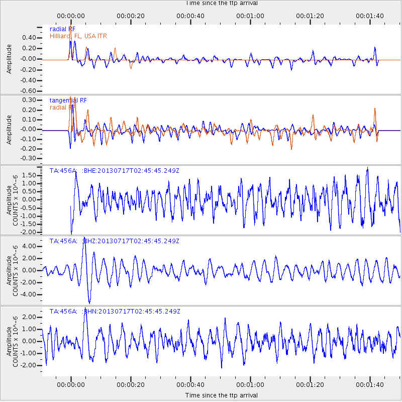
456A Hilliard, FL, USA - Earthquake Result Viewer
*The percent match for this event was below the threshold and hence no stack was calculated.
| Earthquake location: |
Southern Peru |
| Earthquake latitude/longitude: |
-15.7/-71.7 |
| Earthquake time(UTC): |
2013/07/17 (198) 02:37:43 GMT |
| Earthquake Depth: |
7.0 km |
| Earthquake Magnitude: |
6.0 MW, 5.6 MB, 5.8 MS, 5.8 MW |
| Earthquake Catalog/Contributor: |
NEIC PDE/NEIC PDE-W |
|
| Network: |
TA USArray Transportable Network (new EarthScope stations) |
| Station: |
456A Hilliard, FL, USA |
| Lat/Lon: |
30.72 N/82.02 W |
| Elevation: |
26 m |
|
| Distance: |
47.2 deg |
| Az: |
347.9 deg |
| Baz: |
166.438 deg |
| Ray Param: |
$rayparam |
*The percent match for this event was below the threshold and hence was not used in the summary stack. |
|
| Radial Match: |
62.518528 % |
| Radial Bump: |
400 |
| Transverse Match: |
65.138115 % |
| Transverse Bump: |
400 |
| SOD ConfigId: |
512894 |
| Insert Time: |
2013-09-15 20:29:35.215 +0000 |
| GWidth: |
2.5 |
| Max Bumps: |
400 |
| Tol: |
0.001 |
|
Signal To Noise
| Channel | StoN | STA | LTA |
| TA:456A: :BHZ:20130717T02:45:45.249Z | 4.052963 | 2.3051525E-6 | 5.687574E-7 |
| TA:456A: :BHN:20130717T02:45:45.249Z | 1.5698768 | 9.1474527E-7 | 5.82686E-7 |
| TA:456A: :BHE:20130717T02:45:45.249Z | 1.0319328 | 6.437142E-7 | 6.2379473E-7 |
| Arrivals |
| Ps | |
| PpPs | |
| PsPs/PpSs | |


