You are here: Home > Network List > TA - USArray Transportable Network (new EarthScope stations) Stations List
> Station 656A Willston, FL, USA > Earthquake Result Viewer
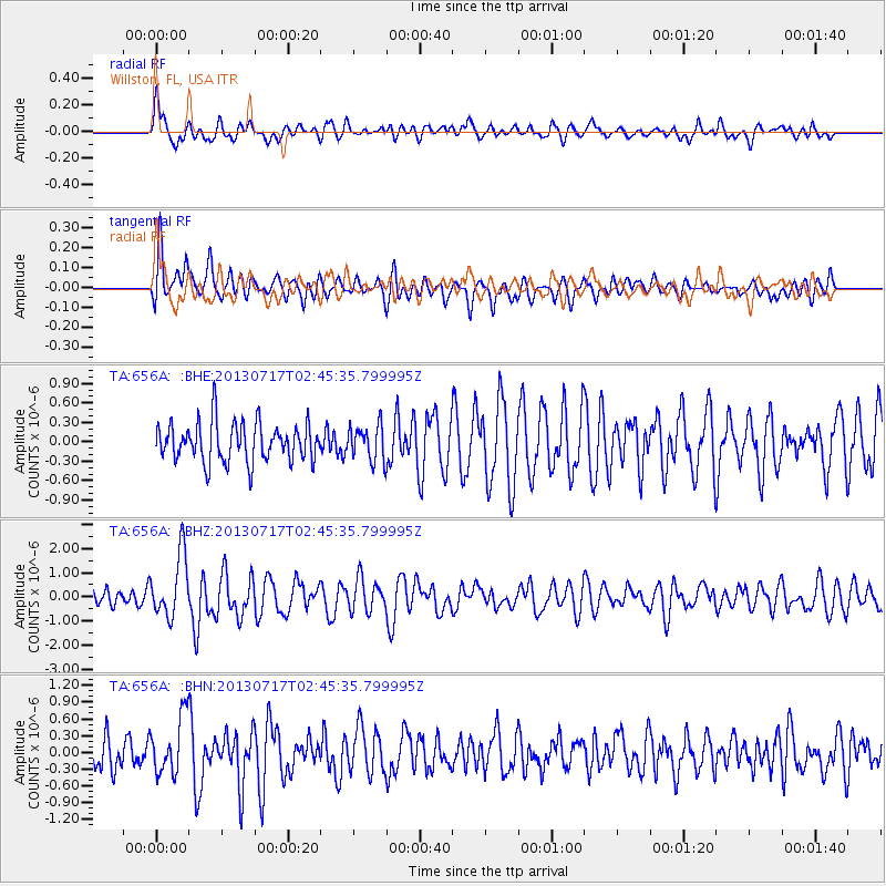
656A Willston, FL, USA - Earthquake Result Viewer
*The percent match for this event was below the threshold and hence no stack was calculated.
| Earthquake location: |
Southern Peru |
| Earthquake latitude/longitude: |
-15.7/-71.7 |
| Earthquake time(UTC): |
2013/07/17 (198) 02:37:43 GMT |
| Earthquake Depth: |
7.0 km |
| Earthquake Magnitude: |
6.0 MW, 5.6 MB, 5.8 MS, 5.8 MW |
| Earthquake Catalog/Contributor: |
NEIC PDE/NEIC PDE-W |
|
| Network: |
TA USArray Transportable Network (new EarthScope stations) |
| Station: |
656A Willston, FL, USA |
| Lat/Lon: |
29.37 N/82.53 W |
| Elevation: |
28 m |
|
| Distance: |
46.0 deg |
| Az: |
346.855 deg |
| Baz: |
165.464 deg |
| Ray Param: |
$rayparam |
*The percent match for this event was below the threshold and hence was not used in the summary stack. |
|
| Radial Match: |
70.145805 % |
| Radial Bump: |
400 |
| Transverse Match: |
71.289246 % |
| Transverse Bump: |
400 |
| SOD ConfigId: |
512894 |
| Insert Time: |
2013-09-15 20:29:56.457 +0000 |
| GWidth: |
2.5 |
| Max Bumps: |
400 |
| Tol: |
0.001 |
|
Signal To Noise
| Channel | StoN | STA | LTA |
| TA:656A: :BHZ:20130717T02:45:35.799995Z | 3.9662836 | 1.2976392E-6 | 3.2716753E-7 |
| TA:656A: :BHN:20130717T02:45:35.799995Z | 2.1013496 | 5.1280165E-7 | 2.440344E-7 |
| TA:656A: :BHE:20130717T02:45:35.799995Z | 0.91789937 | 2.7475616E-7 | 2.9933145E-7 |
| Arrivals |
| Ps | |
| PpPs | |
| PsPs/PpSs | |


