You are here: Home > Network List > TA - USArray Transportable Network (new EarthScope stations) Stations List
> Station 757A Oxford, FL, USA > Earthquake Result Viewer
757A Oxford, FL, USA - Earthquake Result Viewer
| Earthquake location: |
Southern Peru |
| Earthquake latitude/longitude: |
-15.7/-71.7 |
| Earthquake time(UTC): |
2013/07/17 (198) 02:37:43 GMT |
| Earthquake Depth: |
7.0 km |
| Earthquake Magnitude: |
6.0 MW, 5.6 MB, 5.8 MS, 5.8 MW |
| Earthquake Catalog/Contributor: |
NEIC PDE/NEIC PDE-W |
|
| Network: |
TA USArray Transportable Network (new EarthScope stations) |
| Station: |
757A Oxford, FL, USA |
| Lat/Lon: |
28.94 N/82.07 W |
| Elevation: |
22 m |
|
| Distance: |
45.4 deg |
| Az: |
347.26 deg |
| Baz: |
165.973 deg |
| Ray Param: |
0.07128052 |
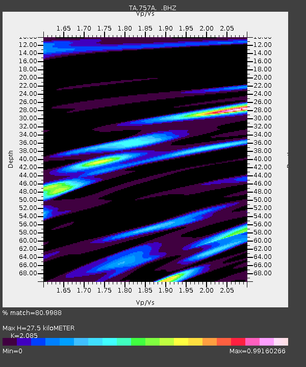
| Estimated Moho Depth: |
27.5 km |
| Estimated Crust Vp/Vs: |
2.09 |
| Assumed Crust Vp: |
5.989 km/s |
| Estimated Crust Vs: |
2.872 km/s |
| Estimated Crust Poisson's Ratio: |
0.35 |
|
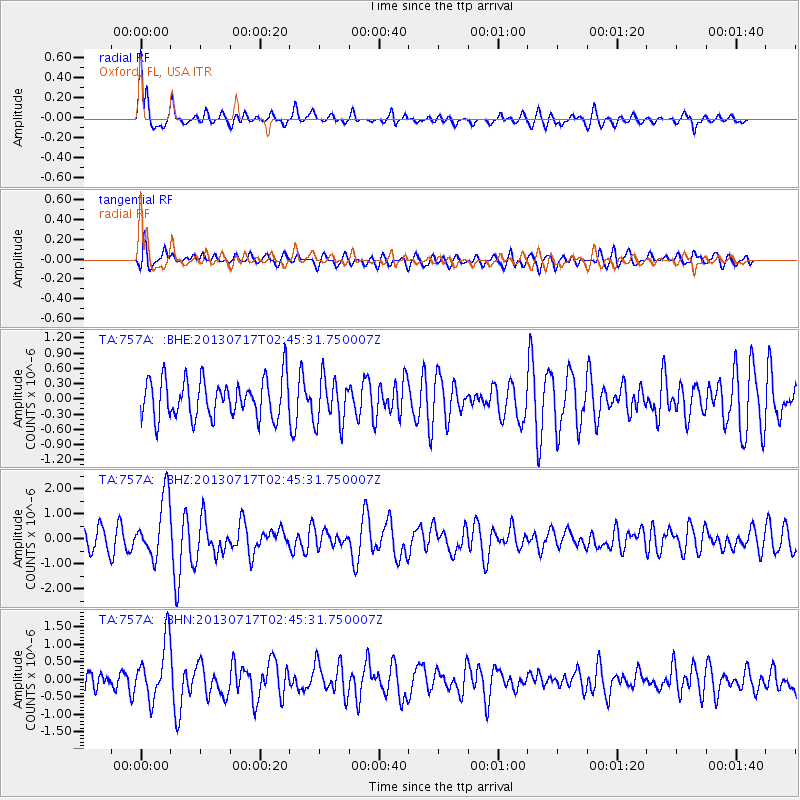
| Radial Match: |
80.9988 % |
| Radial Bump: |
400 |
| Transverse Match: |
68.704254 % |
| Transverse Bump: |
400 |
| SOD ConfigId: |
512894 |
| Insert Time: |
2013-09-15 20:30:05.521 +0000 |
| GWidth: |
2.5 |
| Max Bumps: |
400 |
| Tol: |
0.001 |
|
Signal To Noise
| Channel | StoN | STA | LTA |
| TA:757A: :BHZ:20130717T02:45:31.750007Z | 2.9591966 | 1.217741E-6 | 4.1151068E-7 |
| TA:757A: :BHN:20130717T02:45:31.750007Z | 3.248867 | 8.221676E-7 | 2.5306286E-7 |
| TA:757A: :BHE:20130717T02:45:31.750007Z | 1.1886846 | 4.5171862E-7 | 3.8001556E-7 |
| Arrivals |
| Ps | 5.2 SECOND |
| PpPs | 14 SECOND |
| PsPs/PpSs | 19 SECOND |


