You are here: Home > Network List > UW - Pacific Northwest Regional Seismic Network Stations List
> Station TAKO Tahkenitch, OR CREST BB SMO > Earthquake Result Viewer
TAKO Tahkenitch, OR CREST BB SMO - Earthquake Result Viewer
| Earthquake location: |
Solomon Islands |
| Earthquake latitude/longitude: |
-8.5/157.0 |
| Earthquake time(UTC): |
2007/04/01 (091) 20:39:56 GMT |
| Earthquake Depth: |
10 km |
| Earthquake Magnitude: |
6.8 MB, 7.9 MS, 8.1 MW, 7.7 ME |
| Earthquake Catalog/Contributor: |
WHDF/NEIC |
|
| Network: |
UW Pacific Northwest Regional Seismic Network |
| Station: |
TAKO Tahkenitch, OR CREST BB SMO |
| Lat/Lon: |
43.74 N/124.08 W |
| Elevation: |
46 m |
|
| Distance: |
87.8 deg |
| Az: |
45.369 deg |
| Baz: |
256.253 deg |
| Ray Param: |
0.043029755 |
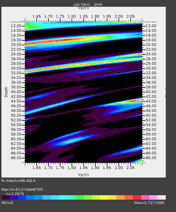
| Estimated Moho Depth: |
43.0 km |
| Estimated Crust Vp/Vs: |
2.10 |
| Assumed Crust Vp: |
6.048 km/s |
| Estimated Crust Vs: |
2.883 km/s |
| Estimated Crust Poisson's Ratio: |
0.35 |
|
| Radial Match: |
96.4614 % |
| Radial Bump: |
247 |
| Transverse Match: |
83.51003 % |
| Transverse Bump: |
323 |
| SOD ConfigId: |
2564 |
| Insert Time: |
2010-02-27 05:05:07.518 +0000 |
| GWidth: |
2.5 |
| Max Bumps: |
400 |
| Tol: |
0.001 |
|

Signal To Noise
| Channel | StoN | STA | LTA |
| UW:TAKO: :BHN:20070401T20:52:14.26501Z | 3.2367272 | 1.3760267E-6 | 4.2512906E-7 |
| UW:TAKO: :BHE:20070401T20:52:14.26501Z | 3.7037177 | 4.248175E-6 | 1.147003E-6 |
| UW:TAKO: :BHZ:20070401T20:52:14.26501Z | 5.2630925 | 1.3418179E-5 | 2.5494855E-6 |
| Arrivals |
| Ps | 7.9 SECOND |
| PpPs | 22 SECOND |
| PsPs/PpSs | 30 SECOND |


