You are here: Home > Network List > UW - Pacific Northwest Regional Seismic Network Stations List
> Station TAKO Tahkenitch, OR CREST BB SMO > Earthquake Result Viewer
TAKO Tahkenitch, OR CREST BB SMO - Earthquake Result Viewer
| Earthquake location: |
Sea Of Okhotsk |
| Earthquake latitude/longitude: |
53.9/152.9 |
| Earthquake time(UTC): |
2008/07/05 (187) 02:12:04 GMT |
| Earthquake Depth: |
633 km |
| Earthquake Magnitude: |
6.8 MB, 7.7 MW, 7.7 MW |
| Earthquake Catalog/Contributor: |
WHDF/NEIC |
|
| Network: |
UW Pacific Northwest Regional Seismic Network |
| Station: |
TAKO Tahkenitch, OR CREST BB SMO |
| Lat/Lon: |
43.74 N/124.08 W |
| Elevation: |
46 m |
|
| Distance: |
52.6 deg |
| Az: |
64.897 deg |
| Baz: |
312.293 deg |
| Ray Param: |
0.063735984 |
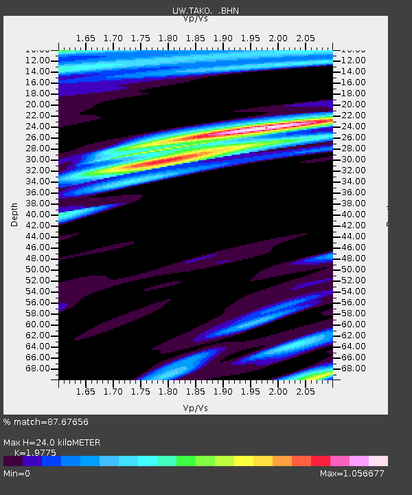
| Estimated Moho Depth: |
24.0 km |
| Estimated Crust Vp/Vs: |
1.98 |
| Assumed Crust Vp: |
6.048 km/s |
| Estimated Crust Vs: |
3.058 km/s |
| Estimated Crust Poisson's Ratio: |
0.33 |
|
| Radial Match: |
87.67656 % |
| Radial Bump: |
400 |
| Transverse Match: |
59.43199 % |
| Transverse Bump: |
400 |
| SOD ConfigId: |
2504 |
| Insert Time: |
2010-02-27 05:05:09.274 +0000 |
| GWidth: |
2.5 |
| Max Bumps: |
400 |
| Tol: |
0.001 |
|
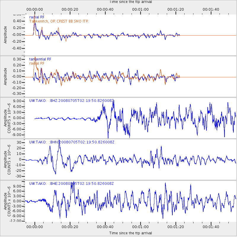
Signal To Noise
| Channel | StoN | STA | LTA |
| UW:TAKO: :BHN:20080705T02:19:50.826008Z | 6.9015117 | 2.5685956E-6 | 3.721787E-7 |
| UW:TAKO: :BHE:20080705T02:19:50.826008Z | 1.8307173 | 6.732201E-7 | 3.6773568E-7 |
| UW:TAKO: :BHZ:20080705T02:19:50.826008Z | 2.2964666 | 6.94747E-7 | 3.0252866E-7 |
| Arrivals |
| Ps | 4.0 SECOND |
| PpPs | 11 SECOND |
| PsPs/PpSs | 15 SECOND |


