You are here: Home > Network List > TA - USArray Transportable Network (new EarthScope stations) Stations List
> Station E47A Iron Bridge, ON, CAN > Earthquake Result Viewer
E47A Iron Bridge, ON, CAN - Earthquake Result Viewer
| Earthquake location: |
Southern Peru |
| Earthquake latitude/longitude: |
-15.7/-71.7 |
| Earthquake time(UTC): |
2013/07/17 (198) 02:37:43 GMT |
| Earthquake Depth: |
7.0 km |
| Earthquake Magnitude: |
6.0 MW, 5.6 MB, 5.8 MS, 5.8 MW |
| Earthquake Catalog/Contributor: |
NEIC PDE/NEIC PDE-W |
|
| Network: |
TA USArray Transportable Network (new EarthScope stations) |
| Station: |
E47A Iron Bridge, ON, CAN |
| Lat/Lon: |
46.45 N/83.28 W |
| Elevation: |
246 m |
|
| Distance: |
62.7 deg |
| Az: |
351.047 deg |
| Baz: |
167.476 deg |
| Ray Param: |
0.060067184 |
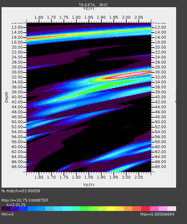
| Estimated Moho Depth: |
30.75 km |
| Estimated Crust Vp/Vs: |
2.01 |
| Assumed Crust Vp: |
6.467 km/s |
| Estimated Crust Vs: |
3.213 km/s |
| Estimated Crust Poisson's Ratio: |
0.34 |
|
| Radial Match: |
83.98659 % |
| Radial Bump: |
312 |
| Transverse Match: |
53.317345 % |
| Transverse Bump: |
400 |
| SOD ConfigId: |
512894 |
| Insert Time: |
2013-09-15 20:31:32.093 +0000 |
| GWidth: |
2.5 |
| Max Bumps: |
400 |
| Tol: |
0.001 |
|

Signal To Noise
| Channel | StoN | STA | LTA |
| TA:E47A: :BHZ:20130717T02:47:37.399971Z | 2.7380228 | 1.304345E-6 | 4.7638207E-7 |
| TA:E47A: :BHN:20130717T02:47:37.399971Z | 1.3006896 | 4.1717476E-7 | 3.2073353E-7 |
| TA:E47A: :BHE:20130717T02:47:37.399971Z | 0.64544326 | 8.4368374E-8 | 1.3071384E-7 |
| Arrivals |
| Ps | 5.0 SECOND |
| PpPs | 14 SECOND |
| PsPs/PpSs | 19 SECOND |


