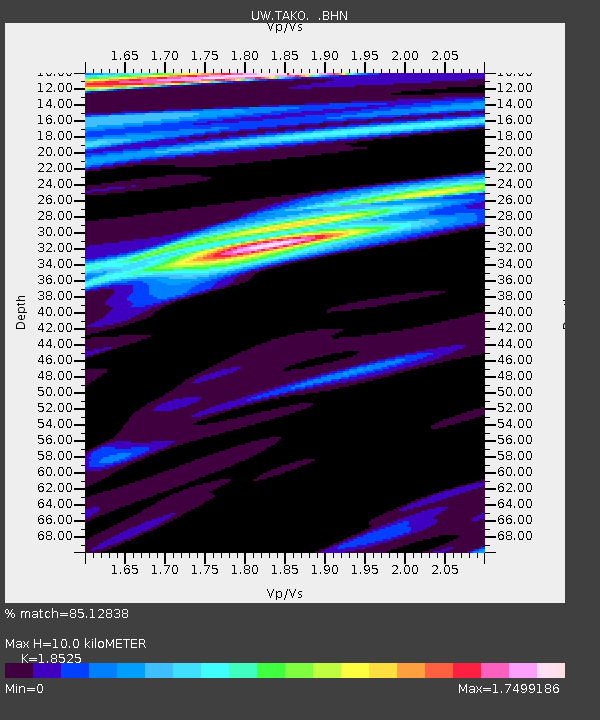
TAKO Tahkenitch, OR CREST BB SMO - Earthquake Result Viewer
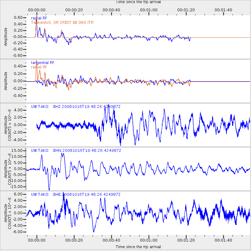
Earthquake location: Near Coast Of Chiapas, Mexico
Earthquake latitude/longitude: 14.4/-92.4
Earthquake time(UTC): 2008/10/16 (290) 19:41:25 GMT
Earthquake Depth: 24 km
Earthquake Magnitude: 6.1 MB, 6.6 MS, 6.7 MW, 6.6 MW
Earthquake Catalog/Contributor: WHDF/NEIC
Network: UW Pacific Northwest Regional Seismic Network
Station: TAKO Tahkenitch, OR CREST BB SMO
Lat/Lon: 43.74 N/124.08 W
Elevation: 46 m
Distance: 39.8 deg
Az: 323.501 deg
Baz: 127.33 deg
Ray Param: 0.07471141
Estimated Moho Depth: 10.0 km
Estimated Crust Vp/Vs: 1.85
Assumed Crust Vp: 6.048 km/s
Estimated Crust Vs: 3.265 km/s
Estimated Crust Poisson's Ratio: 0.29
Radial Match: 85.12838 %
Radial Bump: 342
Transverse Match: 79.77225 %
Transverse Bump: 400
SOD ConfigId: 2556
Insert Time: 2010-02-27 05:05:12.938 +0000
GWidth: 2.5
Max Bumps: 400
Tol: 0.001

Signal To Noise

ChannelStoNSTALTA
UW:TAKO: :BHN:20081016T19:48:26.424987Z8.4975124.207216E-64.951115E-7
UW:TAKO: :BHE:20081016T19:48:26.424987Z2.0192491.3547318E-66.709087E-7
UW:TAKO: :BHZ:20081016T19:48:26.424987Z3.66640541.6962239E-64.626395E-7
Arrivals
Ps1.5 SECOND
PpPs4.4 SECOND
PsPs/PpSs5.9 SECOND